| Mesoscale Discussion 994 | |
| < Previous MD | |

|
|
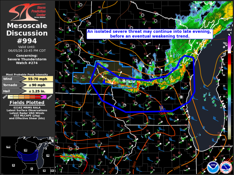
Mesoscale Discussion 0994 NWS Storm Prediction Center Norman OK 0918 PM CDT Fri Jun 05 2026 Areas affected...Parts of southern/eastern WI and adjacent parts of southeast MN/northeast IA Concerning...Severe Thunderstorm Watch 274... Valid 060218Z - 060345Z The severe weather threat for Severe Thunderstorm Watch 274 continues. SUMMARY...An isolated severe threat may continue into late evening, before an eventual weakening trend. DISCUSSION...A large storm cluster is moving southeastward across central WI this evening. While the environment remains somewhat favorable, with MLCAPE of greater than 1500 J/kg and 30-40 kt of effective shear, much of the convection has been undercut by outflow. Small line segments to the east of La Crosse and south of Green Bay have taken on a more favorable north-south orientation, and may pose a localized damaging-wind threat for as long as they keep pace with the outflow. Additionally, a small supercell has developed ahead of the storm cluster, to the southwest of Oshkosh. With 0-1 km SRH of 100-200 m2/s2 (per objective mesoanalysis and the KMKE VWP), this cell may pose some tornado potential for as long as it persists. With the onset of nocturnal cooling/stabilization, a general weakening trend is expected with time later this evening, and additional watch issuance is considered unlikely. ..Dean/Gleason.. 06/06/2026 ...Please see www.spc.noaa.gov for graphic product... ATTN...WFO...GRB...MKX...ARX... LAT...LON 44529194 44079095 43968966 44118879 44398832 44658815 44778793 44708753 43588752 43268776 42958854 42939062 43299168 43899225 44529194 MOST PROBABLE PEAK TORNADO INTENSITY...UP TO 90 MPH MOST PROBABLE PEAK WIND GUST...55-70 MPH MOST PROBABLE PEAK HAIL SIZE...UP TO 1.25 IN |
|
|
Top/All Mesoscale Discussions/Forecast Products/Home |
|
Source link