| Mesoscale Discussion 993 | |
| < Previous MD | |

|
|
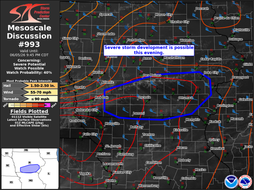
   Mesoscale Discussion 0993
   NWS Storm Prediction Center Norman OK
   0819 PM CDT Fri Jun 05 2026

   Areas affected...portions of southern Iowa into far northern
   Missouri

   Concerning...Severe potential...Watch possible

   Valid 060119Z - 060245Z

   Probability of Watch Issuance...40 percent

   SUMMARY...Isolated severe storm development is possible over
   southern IA this evening. The environment is conditionally
   supportive of a damaging wind and hail risk. The need for a WW is
   unclear.

   DISCUSSION...Evening satellite imagery showed an expanding cumulus
   field along a diffuse Theta-E gradient across southern IA. Over the
   last hour, several cumulus towers have deepened near the boundary.
   Weak ascent from an upper trough visible on WV imagery is
   overspreading the area and could allow for isolated storm
   development/intensification this evening, but this remains highly
   uncertain.

   The air mass along and south of the boundary is very moist with
   surface dewpoints in the upper 60s to low 70s F. This is supporting
   large buoyancy and little inhibition from SPC mesoanalysis. 30-40 kt
   deep-layer flow is supportive of marginal supercells and organized
   clusters. Given the parameter space (3000 J/kg MLCAPE + 30-35 kts
   EWD) these storms would be conditionally capable of damaging winds
   and hail.

   The primary uncertainty remains the development and maintenance of
   stronger storms. While SPC mesoanalysis and the 00z OAX sounding
   show little inhibition, the 00z DVN sounding and the slow evolution
   of the cumulus hint that inhibition remains fairly stout farther
   east. Given this uncertainty, it is unclear how intense or
   widespread these storms could be. CAM guidance suggests more robust
   development may be delayed until the arrival of the clusters ongoing
   farther west and the onset of a 20-25 kt low-level jet later this
   evening. While confidence in the convective evolution is low, some
   severe risk may materialize. Conditions are being monitored for a
   small Severe Thunderstorm Watch.

   ..Lyons/Gleason.. 06/06/2026

   ...Please see www.spc.noaa.gov for graphic product...

   ATTN...WFO...DVN...DMX...EAX...

   LAT...LON   41669314 41739166 41539131 41149127 40659194 40519291
               40539378 40559439 40719487 41269488 41669314

   MOST PROBABLE PEAK TORNADO INTENSITY...UP TO 90 MPH
   MOST PROBABLE PEAK WIND GUST...55-70 MPH
   MOST PROBABLE PEAK HAIL SIZE...1.50-2.50 IN
|
|
|
Top/All Mesoscale Discussions/Forecast Products/Home |
|
Source link