| Mesoscale Discussion 990 | |
| < Previous MD | |

|
|
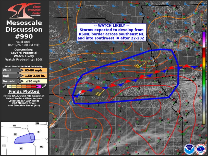
   Mesoscale Discussion 0990
   NWS Storm Prediction Center Norman OK
   0355 PM CDT Fri Jun 05 2026

   Areas affected...far northern Kansas...much of southern
   Nebraska...southwest Iowa and far northwest Missouri

   Concerning...Severe potential...Watch likely

   Valid 052055Z - 052300Z

   Probability of Watch Issuance...80 percent

   SUMMARY...Storms will develop from far northern Kansas across much
   of southern and eastern Nebraska after about 22-23Z. Damaging winds
   and hail will be possible.

   DISCUSSION...Visible satellite shows CU development within the
   surface trough over western KS and intersecting the stationary front
   extending from southern NE into IA. Initial development is most
   likely from northern KS into south-central NE in the next 1-2 hours,
   with additional activity increasing along the stationary front as a
   modest low-level jet increases this evening.

   Localized hail at or above 2.00" may occur, along with an eventual
   mixed-mode damaging wind threat as storms travel within the
   moderately unstable zone near the boundary. Visible imagery and
   surface observations show ample moisture in place, which is also
   beneath steep midlevel lapse rates. Deep-layer shear is a bit
   marginal for supercells, but deep-layer mean winds speeds as well as
   the increasing southerly winds at 850 mb should support accelerating
   eastward propagating clusters, and perhaps some cells splits.

   ..Jewell/Mosier.. 06/05/2026

   ...Please see www.spc.noaa.gov for graphic product...

   ATTN...WFO...DMX...EAX...OAX...TOP...GID...GLD...

   LAT...LON   40429476 39939525 39699925 39699999 39960009 40479990
               40819962 41099881 41329786 41779616 41819549 41769505
               41419483 41159473 40429476

   MOST PROBABLE PEAK TORNADO INTENSITY...UP TO 90 MPH
   MOST PROBABLE PEAK WIND GUST...65-80 MPH
   MOST PROBABLE PEAK HAIL SIZE...1.50-2.50 IN
|
|
|
Top/All Mesoscale Discussions/Forecast Products/Home |
|
Source link