| Mesoscale Discussion 986 | |
| < Previous MD | |

|
|
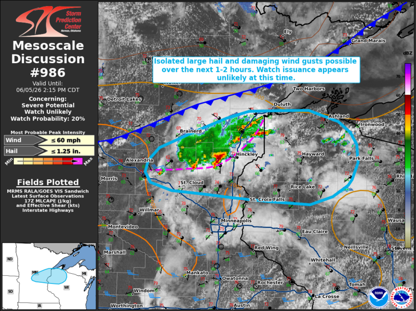
   Mesoscale Discussion 0986
   NWS Storm Prediction Center Norman OK
   1245 PM CDT Fri Jun 05 2026

   Areas affected...portions of central Minnesota into northern
   Wisconsin

   Concerning...Severe potential...Watch unlikely

   Valid 051745Z - 051915Z

   Probability of Watch Issuance...20 percent

   SUMMARY...Isolated large hail and damaging wind gusts are possible
   through early afternoon. Watch issuance is unlikely at this time.

   DISCUSSION...Aided by modest forcing ahead of a subtle, mid-level
   shortwave trough, thunderstorm coverage has increased across
   portions of central/east-central Minnesota ahead of a weak cold
   front/surface boundary as of early afternoon. While objective
   analysis indicates that available buoyancy remains weak (generally
   500 to locally 1000 J/kg MLCAPE), continued insolation will support
   a destabilizing air mass through the afternoon. Modestly strong
   mid-to-upper level flow sampled by the DLH VWP and effective shear
   of around 25-30 kts are contributing to modest updraft organization,
   with marginal supercell structures noted per recent radar imagery
   from KMPX. Despite generally poor mid-level lapse rates sampled by
   the 12z MPX observed sounding, a couple of instances of small to
   marginally severe hail may be possible over the next 1-2 hours with
   this activity. Steepening low-level lapse rates may also promote
   some potential for occasional strong to damaging wind gusts,
   especially if convection is able to organize into one or more
   convective clusters.

   While the exact evolution of this convective activity remains
   somewhat uncertain, latest guidance indicates that this activity may
   eventually evolve into one or more convective clusters as it
   progresses eastward. Weak effective shear is likely to somewhat
   limit convective organization. Thus, watch issuance appears unlikely
   at this time. Continued insolation of a moist low-level air mass
   will then yield further destabilization and the potential for some
   increase in severe potential later this afternoon. Trends will
   continue to be monitored.

   ..Chalmers/Mosier.. 06/05/2026

   ...Please see www.spc.noaa.gov for graphic product...

   ATTN...WFO...DLH...ARX...MPX...

   LAT...LON   45399297 45439357 45489433 45619480 45769492 45949486
               46149461 46449373 46619313 46739263 46749191 46739130
               46559063 46399037 46209023 45929022 45669036 45569045
               45399078 45279128 45329214 45399297

   MOST PROBABLE PEAK WIND GUST...UP TO 60 MPH
   MOST PROBABLE PEAK HAIL SIZE...UP TO 1.25 IN
|
|
|
Top/All Mesoscale Discussions/Forecast Products/Home |
|
Source link