|
|
| Mesoscale Discussion 986 | |
| < Previous MD Next MD > | |

|
|
   Mesoscale Discussion 0986
   NWS Storm Prediction Center Norman OK
   0436 PM CDT Sun May 26 2024

   Areas affected...Western Virginia

   Concerning...Severe potential...Severe Thunderstorm Watch likely

   Valid 262136Z - 262330Z

   Probability of Watch Issuance...95 percent

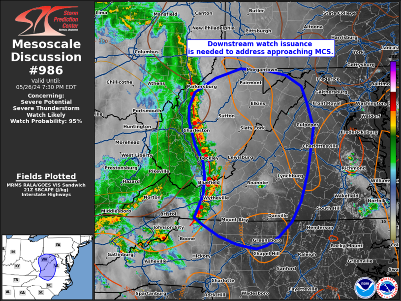
   SUMMARY...Downstream severe thunderstorm watch issuance will be
   needed within the next 30 minutes to address an approaching MCS.

   DISCUSSION...A well-organized QLCS continues to push east across the
   southern Appalachians and has a history of producing damaging (50-60
   mph) winds. GOES imagery shows that this line continues to produce
   robust embedded updrafts despite moving into a region with weaker
   deep-layer shear. This may be due to compensating effects from
   higher SBCAPE on the eastern side of the Appalachians. Given the
   buoyant air mass and steep low-level lapse rates downstream, the
   severe/damaging wind threat should continue. Watch issuance is
   likely within the next 30 minutes.

   ..Moore/Smith.. 05/26/2024

   ...Please see www.spc.noaa.gov for graphic product...

   ATTN...WFO...AKQ...LWX...RAH...RNK...PBZ...RLX...

   LAT...LON   36608128 37088106 37448101 37768107 38108128 38618145
               38918146 39218131 39528076 39718008 39687938 39587886
               39357845 39017832 38477815 37577831 36947850 36527873
               36217907 36027939 35957966 36058016 36218064 36478110
               36608128
|
|
|
Top/All Mesoscale Discussions/Forecast Products/Home |
|


