| Mesoscale Discussion 982 | |
| < Previous MD | |

|
|
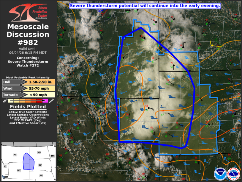
Mesoscale Discussion 0982 NWS Storm Prediction Center Norman OK 0546 PM CDT Thu Jun 04 2026 Areas affected...Eastern MT...northeast WY...western SD...southwest ND Concerning...Severe Thunderstorm Watch 272... Valid 042246Z - 050015Z The severe weather threat for Severe Thunderstorm Watch 272 continues. SUMMARY...Severe thunderstorm potential will continue into the early evening. DISCUSSION...Scattered strong storms are ongoing as of 2230 UTC from southeast MT/southwest ND into northeast WY. The environment remains generally favorable for organized convection, with MLCAPE of near/above 1000 J/kg and effective shear of 40+ kt. A low-amplitude midlevel shortwave trough moving across eastern MT should help to sustain convection into the early evening, with at least transient supercells possible. In the short term, isolated large hail and localized severe gusts will remain possible with the strongest storms. Cooler temperatures and stronger MLCINH are in place east of the Black Hills, but low-level moisture also becomes more favorable with eastward extent, along/north of a surface boundary draped from southwest into south-central SD. If a larger-scale outflow can develop from ongoing convection, there will be some potential for upscale growth near the intersection of the outflow and surface boundary during the evening. ..Dean.. 06/04/2026 ...Please see www.spc.noaa.gov for graphic product... ATTN...WFO...BIS...UNR...CYS...BYZ...GGW...RIW... LAT...LON 47500497 46620348 45930255 45350225 44530235 43600260 43290274 43210296 43310351 43420474 43440598 44110606 45280624 47140590 47500497 MOST PROBABLE PEAK TORNADO INTENSITY...UP TO 90 MPH MOST PROBABLE PEAK WIND GUST...55-70 MPH MOST PROBABLE PEAK HAIL SIZE...1.50-2.50 IN |
|
|
Top/All Mesoscale Discussions/Forecast Products/Home |
|
Source link