|
|
| Mesoscale Discussion 982 | |
| < Previous MD Next MD > | |

|
|
   Mesoscale Discussion 0982
   NWS Storm Prediction Center Norman OK
   0306 PM CDT Sun May 26 2024

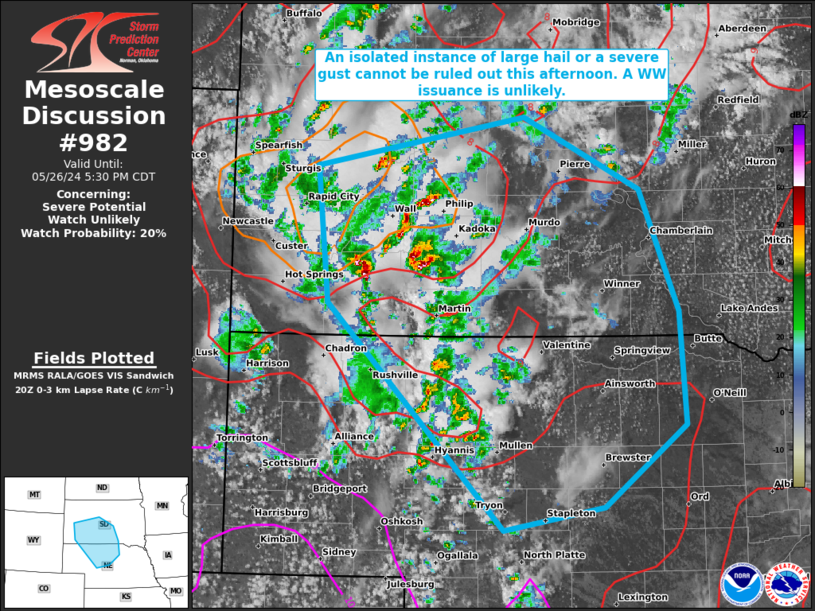
   Areas affected...portions of western and southern South Dakota into
   western and northern Nebraska

   Concerning...Severe potential...Watch unlikely

   Valid 262006Z - 262230Z

   Probability of Watch Issuance...20 percent

   SUMMARY...A couple instances of large hail or severe gusts are
   possible through the remainder of the afternoon. Given the sparse
   nature of the severe threat, a WW issuance is not expected.

   DISCUSSION...Scattered multicellular/briefly transient supercellular
   thunderstorms have been percolating in intensity over the past few
   hours, with at least 1 report received of hail over 1 inch in
   diameter. These storms are developing over marginally buoyant
   airmass characterized by mainly steep low-level lapse rates. Given
   limited deep-layer shear, any storm that becomes strong should only
   do so for short periods of time, and a brief burst of marginally
   severe hail/wind cannot be completely ruled out. Some storms may
   merge cold pools later this afternoon, which may increase the severe
   gust threat slightly. Nonetheless, the severe threat will be
   isolated and brief at best, precluding the need of a WW issuance.

   ..Squitieri/Bunting.. 05/26/2024

   ...Please see www.spc.noaa.gov for graphic product...

   ATTN...WFO...FSD...ABR...LBF...UNR...

   LAT...LON   41380096 43260295 44390308 44800073 44219942 43209899
               42259892 41589983 41380096
|
|
|
Top/All Mesoscale Discussions/Forecast Products/Home |
|


