| Mesoscale Discussion 978 | |
| < Previous MD | |

|
|
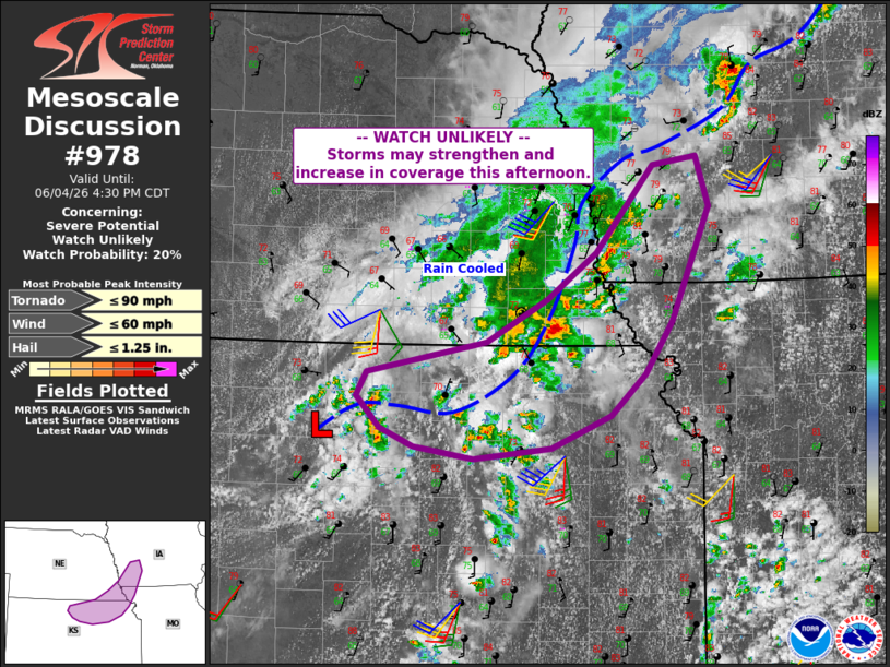
   Mesoscale Discussion 0978
   NWS Storm Prediction Center Norman OK
   0129 PM CDT Thu Jun 04 2026

   Areas affected...parts of northeast Kansas into southeast Nebraska
   and vicinity

   Concerning...Severe potential...Watch unlikely

   Valid 041829Z - 042130Z

   Probability of Watch Issuance...20 percent

   SUMMARY...A few strong to severe storms are possible from northern
   Kansas into southwest Iowa late this afternoon. Locally damaging
   gusts or a brief/weak tornado cannot be ruled out.

   DISCUSSION...Satellite imagery shows an MCV over north-central KS
   and into south-central NE, while surface obs show a weak low near
   Russell KS. East of this feature, a leading outflow extends from
   just west of the NE/IA border southwestward toward the surface low.


   A warming air mass with southerly winds and upper 60s F dewpoints is
   aiding the development of thunderstorms near the boundary in
   southeast NE and trailing into north-central KS. The 18Z OAX and TOP
   soundings show high PWAT but poor lapse rates overall and lightly
   veering winds with height.

   As heating continues, the zone ahead of the MCV should continue to
   see increased storm coverage and intensity. Low-level shear near the
   modifying outflow and ahead of the MCV may increase later today,
   possibly supporting isolated supercells. While deep-layer shear is
   marginal, the very moist air mass combined with locally stronger 0-1
   SRH may support a brief/weak tornado or two. Otherwise, marginal
   hail or localized damaging gusts may occur.

   ..Jewell/Mosier.. 06/04/2026

   ...Please see www.spc.noaa.gov for graphic product...

   ATTN...WFO...DMX...EAX...OAX...TOP...ICT...GID...

   LAT...LON   39749857 40039715 40429643 40859585 41649517 41729465
               41269450 40229495 39749527 39369567 39059639 38959731
               39079801 39249841 39529869 39749857

   MOST PROBABLE PEAK TORNADO INTENSITY...UP TO 90 MPH
   MOST PROBABLE PEAK WIND GUST...UP TO 60 MPH
   MOST PROBABLE PEAK HAIL SIZE...UP TO 1.25 IN
|
|
|
Top/All Mesoscale Discussions/Forecast Products/Home |
|
Source link