| Mesoscale Discussion 971 | |
| < Previous MD Next MD > | |

|
|
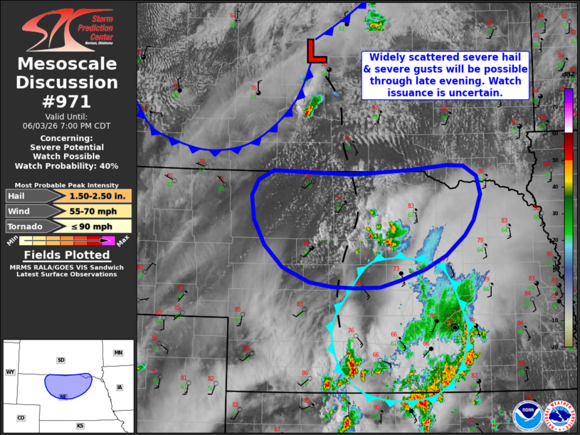
Mesoscale Discussion 0971 NWS Storm Prediction Center Norman OK 0507 PM CDT Wed Jun 03 2026 Areas affected...North-central Nebraska Concerning...Severe potential...Watch possible Valid 032207Z - 040000Z Probability of Watch Issuance...40 percent SUMMARY...Thunderstorms may increase in coverage through the evening hours. However, weaker deep-layer shear with southward extent casts uncertainty on storm longevity and whether additional watch issuance will be needed. DISCUSSION...Over the past hour, deepening cumulus and initial stages of sustained thunderstorm development have become apparent along a surface trough and along/north of a northward propagating outflow boundary across north-central NE. This activity is maturing within the regional buoyancy maximum where lifted indices are on the order of -6 to -8 C and SBCAPE is estimated upwards of 3000 J/kg. Consequently, the intensity and coverage of convection should increase over the next couple of hours to the south of WW 271. However, based on latest forecast soundings and RAP mesoanalysis, weaker mid/upper-level flow with southward extent is contributing to effective bulk shear values on the order of 25 knots. While supportive of marginal supercells, given the tight clustering of developing convection evident in GOES imagery, loosely organized multicells should be the most probable storm mode with an attendant threat for isolated large hail and severe gusts. Additional thunderstorm development is anticipated along the southward advancing cold front later this evening, but focused frontal forcing should promote more linear modes and a predominant wind threat. Regardless, the marginal shear environment coupled with the relatively confined spatial corridor between WW 271 and a cold pool across south-central NE casts uncertainty on how long-lived and/or widespread the severe threat will be. ..Moore/Guyer.. 06/03/2026 ...Please see www.spc.noaa.gov for graphic product... ATTN...WFO...FSD...OAX...GID...LBF...UNR... LAT...LON 41430022 41500061 41690110 42000142 42350162 42660166 42880154 43010126 42969983 43019874 43079811 43069779 42929756 42679749 42339762 42139778 41859811 41679848 41529894 41429933 41419977 41430022 MOST PROBABLE PEAK TORNADO INTENSITY...UP TO 90 MPH MOST PROBABLE PEAK WIND GUST...55-70 MPH MOST PROBABLE PEAK HAIL SIZE...1.50-2.50 IN |
|
|
Top/All Mesoscale Discussions/Forecast Products/Home |
|
Source link