| Mesoscale Discussion 913 | |
| < Previous MD Next MD > | |

|
|
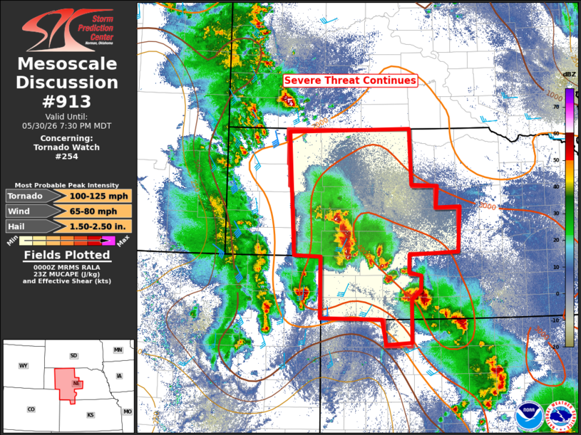
Mesoscale Discussion 0913 NWS Storm Prediction Center Norman OK 0701 PM CDT Sat May 30 2026 Areas affected...parts of western Nebraska Concerning...Tornado Watch 254... Valid 310001Z - 310130Z The severe weather threat for Tornado Watch 254 continues. SUMMARY...Severe thunderstorms capable of producing very large hail and damaging winds will continue this evening. The tornado potential may increase slightly around sunset before waning much later this evening. The severe threat continues. DISCUSSION...Thunderstorms continue to develop in arc from northeast Colorado east into western Nebraska then southeast into central Kansas this evening. This region is likely being glanced by large-scale ascent associated with the lifting, negatively tilted short-wave trough over central Colorado and eastern Wyoming. Additionally, this area is likely experiencing large-scale ascent associated with a 300-mb subtropical jet and subtle short-wave trough lifting northeast across the central US. MUCAPE values across the region are quite extreme, with a reservoir of 4000 J/kg along and ahead of the northward moving arc of convection. Deep-layer shear across the line remains on the weaker side for organized convection, with only 25-35 knots objectively analyzed. That said, shear vectors are mostly orthogonal to the initiating boundary and the extreme instability should support a continued threat for large hail and damaging winds. With time this evening, the low-level jet is forecast to forecast to increase around and after sunset. As this happens, strengthening, strongly veering with height, low-level wind fields may support a more favorable environment for a tornado or two. The severe threat continues across the watch this evening. ..Marsh.. 05/31/2026 ...Please see www.spc.noaa.gov for graphic product... ATTN...WFO...GID...LBF...GLD...BOU...CYS... LAT...LON 40020207 40980207 41000261 42950273 42990021 42120017 42109963 41759966 41779916 41069920 41010022 40730022 40689998 40459998 40300017 39620017 39590071 39990079 40020207 MOST PROBABLE PEAK TORNADO INTENSITY...100-125 MPH MOST PROBABLE PEAK WIND GUST...65-80 MPH MOST PROBABLE PEAK HAIL SIZE...1.50-2.50 IN |
|
|
Top/All Mesoscale Discussions/Forecast Products/Home |
|
Source link