| Mesoscale Discussion 907 | |
| < Previous MD Next MD > | |

|
|
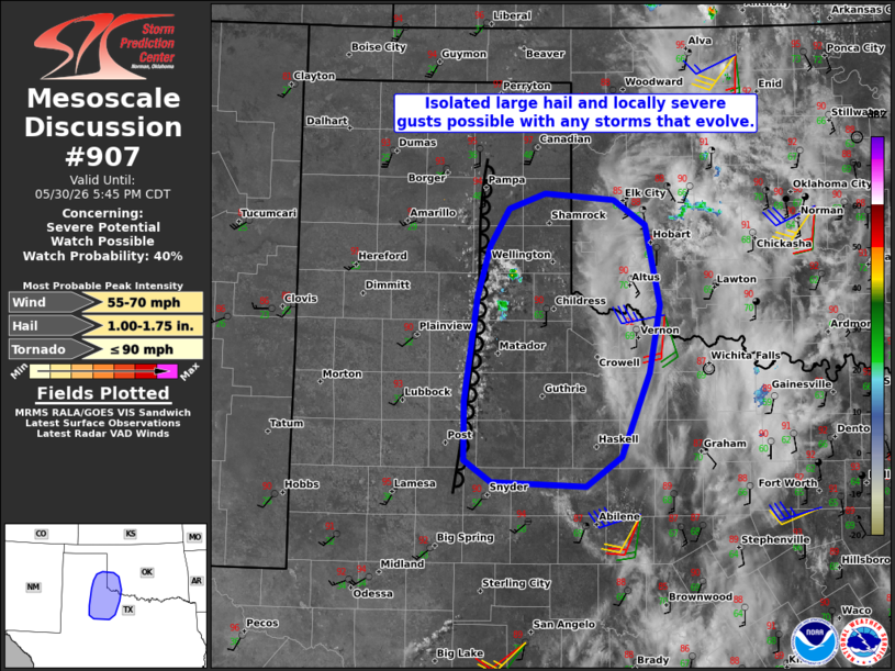
   Mesoscale Discussion 0907
   NWS Storm Prediction Center Norman OK
   0347 PM CDT Sat May 30 2026

   Areas affected...Parts of the eastern TX Panhandle...southwest
   OK...and the Rolling Plains

   Concerning...Severe potential...Watch possible

   Valid 302047Z - 302245Z

   Probability of Watch Issuance...40 percent

   SUMMARY...Isolated large hail and locally severe wind gusts are
   possible with any storms that develop this afternoon.

   DISCUSSION...Boundary-layer cumulus is quickly deepening along a
   north/south-oriented dryline in parts of the central/eastern TX
   Panhandle into the Cap Rock and Rolling Plains. Confidence is
   increasing that isolated thunderstorms will develop over the next
   hour or so. Ahead of the dryline, temperatures have warmed into the
   lower 90s amid lower 60s dewpoints, yielding a moderately unstable
   pre-convective air mass. This buoyancy, coupled with around 30 kt of
   effective shear, will conditionally favor a couple organized cells
   capable of producing large hail and locally severe gusts. It is
   unclear if a watch will be needed, given the potentially isolated
   storm coverage, though convective trends are being monitored.

   ..Weinman/Hart.. 05/30/2026

   ...Please see www.spc.noaa.gov for graphic product...

   ATTN...WFO...OUN...SJT...LUB...AMA...MAF...

   LAT...LON   33020118 33570117 34520103 34990090 35330068 35470029
               35429953 35199918 34449902 33839914 33069944 32799983
               32820087 33020118

   MOST PROBABLE PEAK TORNADO INTENSITY...UP TO 90 MPH
   MOST PROBABLE PEAK WIND GUST...55-70 MPH
   MOST PROBABLE PEAK HAIL SIZE...1.00-1.75 IN
|
|
|
Top/All Mesoscale Discussions/Forecast Products/Home |
|
Source link