| Mesoscale Discussion 905 | |
| < Previous MD | |

|
|
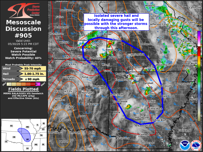
   Mesoscale Discussion 0905
   NWS Storm Prediction Center Norman OK
   0310 PM CDT Sat May 30 2026

   Areas affected...Southeast KS...southwest MO...northern/central
   AR...and far northeast OK

   Concerning...Severe potential...Watch possible

   Valid 302010Z - 302215Z

   Probability of Watch Issuance...40 percent

   SUMMARY...Isolated severe hail and locally damaging gusts will be
   possible with the stronger storms that evolve through the afternoon.

   DISCUSSION...Thunderstorms are gradually increasing in coverage and
   intensity ahead of remnant outflow in southeast KS/southwest MO and
   within a zone of broadly confluent low-level flow extending
   southward into central AR. While large-scale forcing for ascent is
   weak, a moist and uncapped air mass (lower 70s dewpoints) will
   continue to promote widely spaced thunderstorms through this
   corridor for the remainder of the afternoon. While the severe risk
   is expected to remain somewhat unfocused, a strongly unstable air
   mass and 30-40 kt of effective shear will favor a few organized
   clusters and perhaps supercell structures. Isolated severe hail and
   locally damaging gusts are possible with the stronger/loner-lived
   cells. A watch is not currently expected, though convective trends
   are being monitored.

   ..Weinman/Hart.. 05/30/2026

   ...Please see www.spc.noaa.gov for graphic product...

   ATTN...WFO...LZK...SGF...EAX...TSA...TOP...ICT...

   LAT...LON   34419348 35169401 36069466 36649520 37129591 37609598
               37929563 38059508 37889368 37389257 36769191 35819152
               34659150 34199203 34119272 34419348

   MOST PROBABLE PEAK TORNADO INTENSITY...UP TO 90 MPH
   MOST PROBABLE PEAK WIND GUST...55-70 MPH
   MOST PROBABLE PEAK HAIL SIZE...1.00-1.75 IN
|
|
|
Top/All Mesoscale Discussions/Forecast Products/Home |
|
Source link