|
|
| Mesoscale Discussion 905 | |
| < Previous MD | |

|
|
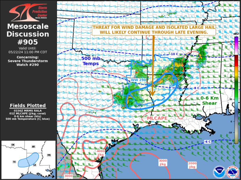
Mesoscale Discussion 0905 NWS Storm Prediction Center Norman OK 0858 PM CDT Wed May 22 2024 Areas affected...East Texas...Northern Louisiana Concerning...Severe Thunderstorm Watch 290... Valid 230158Z - 230400Z The severe weather threat for Severe Thunderstorm Watch 290 continues. SUMMARY...A threat for wind damage and isolated large hail will likely continue through late evening from east Texas into northern Louisiana. DISCUSSION...A large MCS is currently ongoing from east Texas into northern Louisiana and far southern Arkansas. The MCS is located within a moderately unstable airmass, with the RAP analyzing MLCAPE in the 2000 to 3000 J/kg range across much of the Sabine River Valley. In addition, the RAP shows a belt of strong mid-level flow from north Texas extending eastward into the lower Mississippi Valley. This stronger flow is being sampled by the WSR-88D VWP at Fort Polk, LA, which has 0-6 km shear near 50 knots. RAP forecast soundings nearby have steep mid-level lapse rates with veering winds from the surface to near 700 mb. This should continue to support a severe threat with the stronger cells embedded in the MCS. Wind damage will be the greatest threat, although isolated large hail will also be possible. ..Broyles.. 05/23/2024 ...Please see www.spc.noaa.gov for graphic product... ATTN...WFO...JAN...LCH...SHV...HGX...FWD... LAT...LON 31259274 31879204 32299178 32689177 32929196 33099223 33089264 32959287 32589335 32189417 31949512 31699551 31179562 30809543 30769452 30959356 31259274 |
|
|
Top/All Mesoscale Discussions/Forecast Products/Home |
|


