| Mesoscale Discussion 892 | |
| < Previous MD | |
|
|
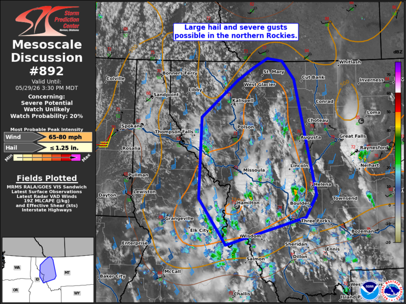
   Mesoscale Discussion 0892
   NWS Storm Prediction Center Norman OK
   0230 PM CDT Fri May 29 2026

   Areas affected...Portions of the northern Rockies

   Concerning...Severe potential...Watch unlikely

   Valid 291930Z - 292130Z

   Probability of Watch Issuance...20 percent

   SUMMARY...Scattered storms may produce isolated large hail and
   severe winds this afternoon into the early evening. A watch is not
   currently anticipated.

   DISCUSSION...Convection continues to increase within the higher
   terrain of western Montana. A few thunderstorms have also developed
   within the last hour. A belt of southerly upper level winds is
   promoting around 30 kt of effective shear per the KMSX VAD.
   Temperatures may remain a bit on the cool side, especially now that
   anvil clouds are spreading north. Some locations of northwest
   Montana may be able to warm further by late afternoon. Overall, 1000
   to perhaps near 1500 J/kg MLCAPE can be expected. Given the low 50s
   F dewpoints within the higher terrain, scattered storms are
   probable. This may lead to numerous storm interactions since the
   deep-layer shear is somewhat marginal. The strongest storms will be
   capable of large hail and severe wind gusts this afternoon/early
   evening.

   ..Wendt/Hart.. 05/29/2026

   ...Please see www.spc.noaa.gov for graphic product...

   ATTN...WFO...TFX...MSO...OTX...

   LAT...LON   45501444 46391518 47931512 48631412 48881366 49061327
               49001286 48651253 46441193 46031223 45501444

   MOST PROBABLE PEAK WIND GUST...65-80 MPH
   MOST PROBABLE PEAK HAIL SIZE...UP TO 1.25 IN
|
|
|
Top/All Mesoscale Discussions/Forecast Products/Home |
|
Source link