|
|
| Mesoscale Discussion 892 | |
| < Previous MD | |

|
|
   Mesoscale Discussion 0892
   NWS Storm Prediction Center Norman OK
   1212 PM CDT Wed May 22 2024

   Areas affected...Southwest TX...Central/North-Central TX...Northeast
   TX

   Concerning...Severe potential...Watch likely

   Valid 221712Z - 221915Z

   Probability of Watch Issuance...80 percent

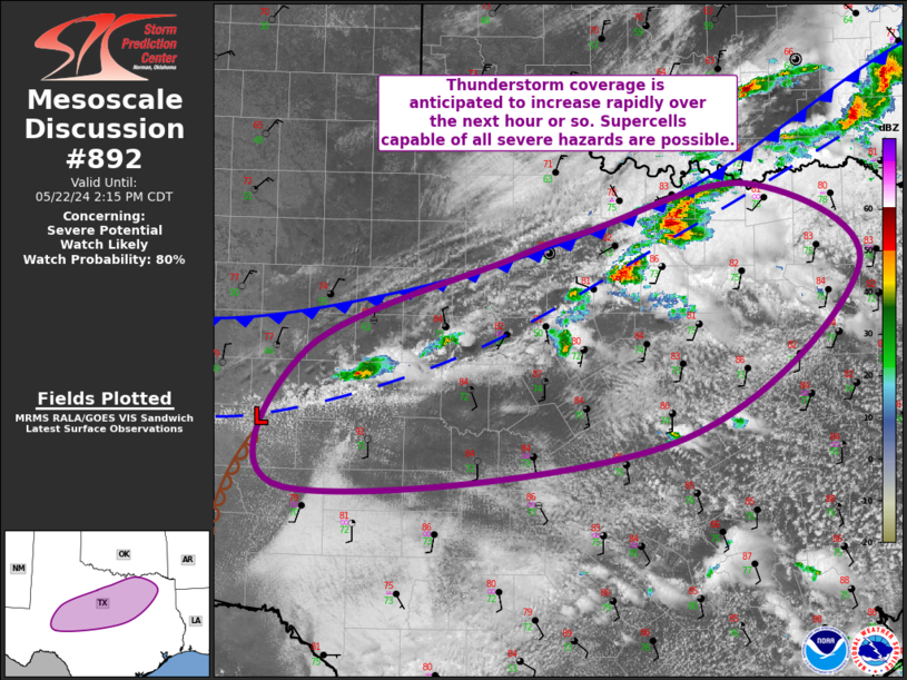
   SUMMARY...Thunderstorm coverage is expected to increase quickly over
   the next hour or so. Environmental conditions support severe
   thunderstorms capable of all severe hazards, including very large
   hail up to 3-4" in diameter. One or more watches may be needed
   across this area to address the anticipated severe potential.

   DISCUSSION...Recent surface analysis places a cold front from just
   north of GYI in Grayson county southwestward to about 50 miles north
   of ABI and then more east-southeastward into the Permian Basin. Weak
   surface troughing precedes the cold front, demarcated by a wind
   shift from southerly south of the boundary to northerly north of it.
   This troughing was likely influential in the recent intensification
   of the cells in north-central TX.

   General expectation is for thunderstorm coverage to increase as
   these boundaries continue southward/southeastward throughout the
   day. The airmass from southwest TX into north-central/central and
   northeast TX is characterized by ample low-level moisture and very
   strong buoyancy. Recent mesoanalysis estimates MLCAPE is over 3000
   J/kg for this entire region. Vertical shear is quite strong too,
   with effective bulk shear values in the 50 to 60 kt. Some minimal
   convective inhibition likely remains, but this should erode quickly
   over the next hour or so, with robust thunderstorm development
   anticipated along and ahead of these boundaries. An initially more
   cellular mode should favor very large hail up to 3-4" in diameter as
   the primary risk. Given that discrete supercells are possible
   initially, some tornado potential exists as well. Over time,
   interactions between these storms and their cold pools should result
   in upscale growth into one or more convective line. Given the
   overall environment, these convective lines could produce severe
   gusts. One or more watches may be needed across this area to address
   the anticipated severe potential.

   ..Mosier/Hart.. 05/22/2024

   ...Please see www.spc.noaa.gov for graphic product...

   ATTN...WFO...SHV...FWD...OUN...SJT...MAF...

   LAT...LON   32190117 33079892 33319812 33739637 32959514 31349718
               30910140 32190117
|
|
|
Top/All Mesoscale Discussions/Forecast Products/Home |
|


