| Mesoscale Discussion 891 | |
| < Previous MD Next MD > | |
|
|
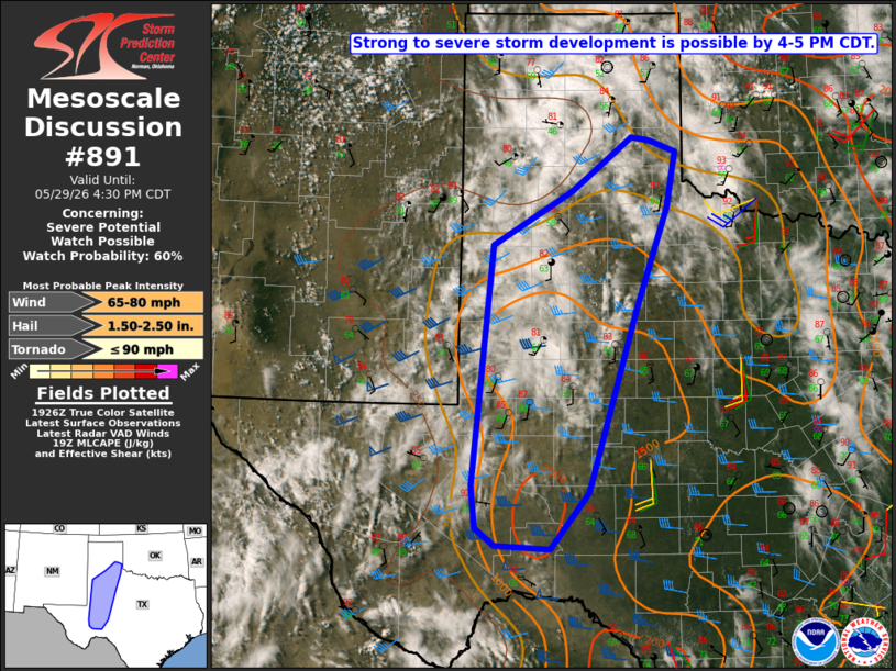
   Mesoscale Discussion 0891
   NWS Storm Prediction Center Norman OK
   0229 PM CDT Fri May 29 2026

   Areas affected...Parts of the TX South Plains/Permian Basin vicinity

   Concerning...Severe potential...Watch possible

   Valid 291929Z - 292130Z

   Probability of Watch Issuance...60 percent

   SUMMARY...Severe storms may develop by 4-5 PM CDT, with a threat of
   hail and severe gusts. Watch issuance is possible.

   DISCUSSION...Relatively strong heating is underway across parts of
   west TX this afternoon, though some areas of mid/upper-level clouds
   persist. Low-level south/southeasterly flow to the east of a weak
   surface trough is maintaining sufficient low-level moisture for
   moderate destabilization, with MLCAPE increasing to near/above 1500
   J/kg across parts of the TX South Plains and Permian Basin.
   Decreasing CINH and a subtle midlevel shortwave trough near the
   TX/NM border will support scattered thunderstorm development by late
   afternoon. An approaching mid/upper-level subtropical jet maximum
   will lead to strengthening deep-layer shear (with effective shear of
   40+ kt), and a few organized cells or clusters may evolve with time.

   Isolated large hail will be possible, including conditional
   potential for 2+ inch diameter hail if any sustained supercells
   develop. Relatively deep mixing and steep low-level lapse rates will
   encourage increasing outflow with time, with an attendant threat of
   at least isolated severe gusts (potentially 75+ mph). Issuance of
   one or more watches is possible later this afternoon in order to
   address these threats.

   ..Dean/Hart.. 05/29/2026

   ...Please see www.spc.noaa.gov for graphic product...

   ATTN...WFO...SJT...LUB...AMA...MAF...

   LAT...LON   31070288 33830259 34450152 35080070 35030044 34910009
               34260022 33080065 30990130 30340181 30390256 30590282
               31070288

   MOST PROBABLE PEAK TORNADO INTENSITY...UP TO 90 MPH
   MOST PROBABLE PEAK WIND GUST...65-80 MPH
   MOST PROBABLE PEAK HAIL SIZE...1.50-2.50 IN
|
|
|
Top/All Mesoscale Discussions/Forecast Products/Home |
|
Source link