|
|
| Mesoscale Discussion 891 | |
| < Previous MD | |

|
|
   Mesoscale Discussion 0891
   NWS Storm Prediction Center Norman OK
   1128 AM CDT Wed May 22 2024

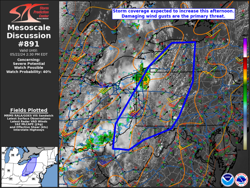
   Areas affected...Western New York into parts upper Ohio Valley

   Concerning...Severe potential...Watch possible

   Valid 221628Z - 221830Z

   Probability of Watch Issuance...40 percent

   SUMMARY...A severe thunderstorm watch is possible for parts of
   western/central New York into the upper Ohio Valley. Damaging winds
   will be the primary threat. An isolated brief tornado and large hail
   may occur with the stronger, more organized activity.

   DISCUSSION...Convection has been most intense right ahead of an MCV
   tracking into northwest Pennsylvania and southwestern New York.
   Destabilization continues to occur ahead of this activity and
   farther south into western Pennsylvania and vicinity. Convection is
   likely to continue in close proximity to the MCV as well as
   additional development within the Allegheny Mountains. Buoyancy may
   be more limited into southeast Ohio/northern West Virginia due to
   cloud cover. Observed morning soundings from the region showed
   mid-level lapse rates around 7 C/km. Deep layer shear this far east
   will be weaker given the displacement from the primary synoptic wave
   in the Upper Midwest. However, some modest increase in shear should
   occur through the day. Storms will be capable of damaging winds
   primarily. Some risk for a brief tornado is also evident given
   modest low-level hodograph turning on area VAD profiles. Large hail
   could occur with the strongest storms, but weak upper-level flow
   will likely keep this threat more isolated. A watch may eventually
   be needed should convective trends warrant.

   ..Wendt/Hart.. 05/22/2024

   ...Please see www.spc.noaa.gov for graphic product...

   ATTN...WFO...BGM...BUF...CTP...LWX...PBZ...RLX...CLE...

   LAT...LON   42257981 43227850 43247715 41577734 40147813 39617857
               39148007 38708090 38748142 38748174 39798164 42257981
|
|
|
Top/All Mesoscale Discussions/Forecast Products/Home |
|


