| Mesoscale Discussion 855 | |
| < Previous MD | |

|
|
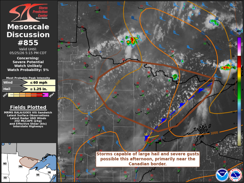
   Mesoscale Discussion 0855
   NWS Storm Prediction Center Norman OK
   0319 PM CDT Mon May 25 2026

   Areas affected...Minnesota Arrowhead

   Concerning...Severe potential...Watch unlikely

   Valid 252019Z - 252215Z

   Probability of Watch Issuance...5 percent

   SUMMARY...A storm or two is possible this afternoon/early evening,
   particularly along the Canadian border. Marginally severe hail and
   severe winds are possible with the most organized storms. A watch is
   not likely.

   DISCUSSION...Subtle influence from a shortwave trough moving through
   Ontario has promoted thunderstorm development north of the Canadian
   border this afternoon. Deepening cumulus are noted on visible
   satellite within the Minnesota Arrowhead. Additional cumulus have
   also developed farther northwest in the drier air. Given the
   mid-level height rises that are occurring and expected to continue,
   storm coverage, and intensity for that matter, in Minnesota are far
   from clear. It does appear possible that a storm or two could
   develop by late afternoon/early evening within a narrow corridor
   from the axis of greater surface moisture and the lake breeze
   boundary. This is more likely to occur near the border given the
   greater influence of the shortwave trough. Temperatures are cold
   enough aloft to support a marginal hail threat despite modest
   moisture/buoyancy. Severe winds could also occur given how
   well-mixed the boundary layer is.

   ..Wendt/Gleason.. 05/25/2026

   ...Please see www.spc.noaa.gov for graphic product...

   ATTN...WFO...DLH...FGF...

   LAT...LON   47319365 47479400 47929445 48189431 48369393 48609325
               48499211 48499204 48309089 48169024 47819038 47049157
               46929222 47319365

   MOST PROBABLE PEAK WIND GUST...UP TO 60 MPH
   MOST PROBABLE PEAK HAIL SIZE...UP TO 1.25 IN
|
|
|
Top/All Mesoscale Discussions/Forecast Products/Home |
|
Source link