| Mesoscale Discussion 836 | |
| < Previous MD | |

|
|
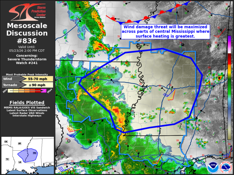
Mesoscale Discussion 0836 NWS Storm Prediction Center Norman OK 1205 PM CDT Sat May 23 2026 Areas affected...Northeast Louisiana into central Mississippi Concerning...Severe Thunderstorm Watch 241... Valid 231705Z - 231900Z The severe weather threat for Severe Thunderstorm Watch 241 continues. SUMMARY...The threat for wind damage will continue into central Mississippi this afternoon. Brief tornadoes also may occur, particularly close the the MCV circulation. DISCUSSION...Filtered surface heating continues ahead of an MCV-driven convective line. The strongest surface heating has occurred in central Mississippi where temperatures are in the low 80s F. KPOE VAD shows around 40 kt of flow within the lowest 3 km after the MCV passed. This should promote at least some threat for wind damage as low-level lapse rates continue to steepen ahead of the activity. The southern extent of the threat is the most uncertain given the influence of convection along the central Gulf Coast. While overall low-level shear remains weak, KPOE VAD did show an increase to around 200 m2/s2 0-3 km SRH just ahead of the MCV. Brief tornadoes remain possible this afternoon. ..Wendt.. 05/23/2026 ...Please see www.spc.noaa.gov for graphic product... ATTN...WFO...JAN...LIX...LCH...SHV... LAT...LON 31498955 31319002 31219080 31079161 31179188 31639207 32039263 32399305 32529298 33269158 33379037 33098946 32638910 32198922 31498955 MOST PROBABLE PEAK TORNADO INTENSITY...UP TO 90 MPH MOST PROBABLE PEAK WIND GUST...55-70 MPH |
|
|
Top/All Mesoscale Discussions/Forecast Products/Home |
|
Source link