| Mesoscale Discussion 818 | |
| < Previous MD | |

|
|
Mesoscale Discussion 0818
NWS Storm Prediction Center Norman OK
0534 PM CDT Thu May 21 2026
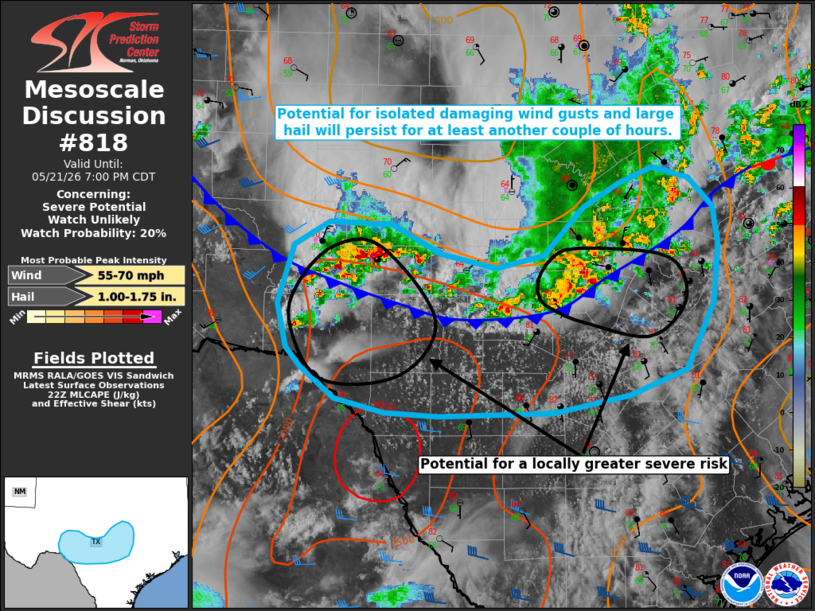
Areas affected...portions of central and south-central Texas
Concerning...Severe potential...Watch unlikely
Valid 212234Z - 220000Z
Probability of Watch Issuance...20 percent
SUMMARY...Some potential for damaging wind gusts and large hail will
persist for at least another couple of hours. Watch issuance remains
unlikely.
DISCUSSION...Widely scattered thunderstorms remain ongoing in close
proximity to a southward surging, convectively-reinforced surface
boundary. Locally greater effective shear of 25-35 kts is supporting
some updraft organization within this corridor, with marginal
supercell structures evident in latest radar imagery in addition to
a bowing segment/cluster noted in Gillespie/Llano Counties.
Expectation is for this activity to gradually shift to the south and
east in conjunction with the aforementioned surface boundary.
Moderately steep mid-level lapse rates and MLCAPE of 1500-2500+ J/kg
will continue to support a threat for isolated large hail with
strong to occasionally damaging wind gusts also possible.
Locally greater severe potential may accompany a bowing cluster as
it progresses eastward toward the Austin, Texas, vicinity. A
separate corridor of locally greater severe potential also appears
possible farther west as southeastward-moving convection encounters
greater instability (noted in latest objective analysis) within a
zone of steeper low- and mid-level lapse rates in the vicinity of
Del Rio. The overall severe risk is expected to remain limited in
coverage/magnitude. Thus, watch issuance remains unlikely at this
time. Trends will continue to be monitored, however.
..Chalmers/Thompson.. 05/21/2026
...Please see www.spc.noaa.gov for graphic product...
ATTN...WFO...FWD...EWX...SJT...
LAT...LON 30210162 30710146 30910112 30890049 30640002 30529947
30629900 31049860 31249826 31389792 31299757 31039732
30719728 30229732 29649760 29439815 29289890 29250003
29270057 29400106 29670140 29830153 30210162
MOST PROBABLE PEAK WIND GUST...55-70 MPH
MOST PROBABLE PEAK HAIL SIZE...1.00-1.75 IN
|
|
|
Top/All Mesoscale Discussions/Forecast Products/Home |
|
Source link