| Mesoscale Discussion 817 | |
| < Previous MD | |

|
|
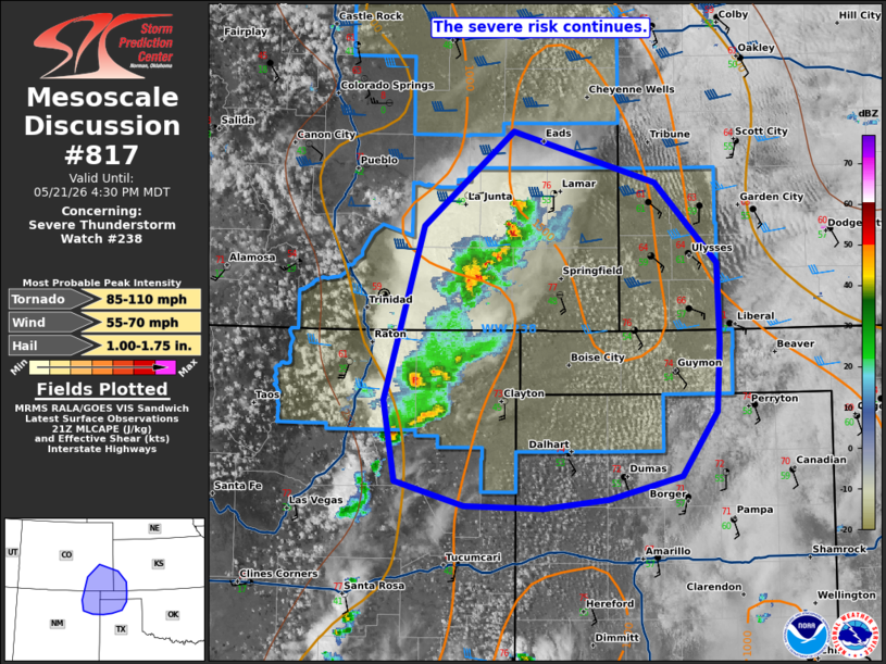
Mesoscale Discussion 0817 NWS Storm Prediction Center Norman OK 0402 PM CDT Thu May 21 2026 Areas affected...southeastern Colorado...southwest Kansas...Northeast New Mexico and the TX/OK Panhandles Concerning...Severe Thunderstorm Watch 238... Valid 212102Z - 212230Z The severe weather threat for Severe Thunderstorm Watch 238 continues. SUMMARY...Ongoing storms should intensify with a risk for hail, damaging gusts and possibly a tornado this evening. DISCUSSION...Across WW238, convection has strengthened this afternoon with a mix of supercellular and linear structures now apparent over southeast CO and northeast NM. These storms are moving into a moderately unstable environment with SBCAPE of 1000-2000 J/kg. Vertical shear remains supportive of organized storms. Convection should continue to intensify as it moves east/southeast this afternoon/evening. Hail should remain the primary risk given steep mid-level lapse rates. However, clustering and the linear segments will also support some damaging wind risk this evening. A brief tornado is also possible later this evening with any discrete supercells able to interact with an increasing low-level jet. Given this, the severe threat continues for much of WW238. ..Lyons.. 05/21/2026 ...Please see www.spc.noaa.gov for graphic product... ATTN...WFO...DDC...AMA...PUB...ABQ... LAT...LON 38540306 38140169 37510109 36890106 36360110 35860144 35670214 35610277 35630353 35810421 36440431 37800394 38540306 MOST PROBABLE PEAK TORNADO INTENSITY...85-110 MPH MOST PROBABLE PEAK WIND GUST...55-70 MPH MOST PROBABLE PEAK HAIL SIZE...1.00-1.75 IN |
|
|
Top/All Mesoscale Discussions/Forecast Products/Home |
|
Source link