| Mesoscale Discussion 808 | |
| < Previous MD | |
|
|
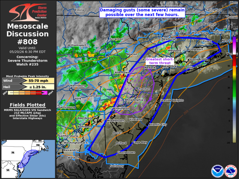
Mesoscale Discussion 0808 NWS Storm Prediction Center Norman OK 0429 PM CDT Wed May 20 2026 Areas affected...portions of southwestern Connecticut into extreme southeast New York...New Jersey...much of Delaware...extreme eastern Maryland Concerning...Severe Thunderstorm Watch 235... Valid 202129Z - 202230Z The severe weather threat for Severe Thunderstorm Watch 235 continues. SUMMARY...Damaging to severe gusts remain a concern across portions of the Mid-Atlantic. The best chance for a severe gust exists with the north-to-south oriented portion of the line. DISCUSSION...Multicellular convection has loosely organized into a progressive MCS across portions of the Mid Atlantic. In the last few hours, several damaging gusts have been received. Preceding the storms is a well-mixed boundary layer, characterized by over 1500 J/kg MLCAPE due to 8-9 C/km 0-3 km lapse rates overlapping 90+ F surface temperatures. Furthermore, vertical speed shear, while moderate (e.g. 25 kts per 21Z mesoanalysis), is oriented roughly normal to the MCS leading line. As such, damaging gusts are expected to continue for a few more hours. The best chance for damaging gusts will be with the northern portions of the MCS (from PHL to areas west of NYC) given the most favorable alignment with the deep-layer shear vector. ..Squitieri.. 05/20/2026 ...Please see www.spc.noaa.gov for graphic product... ATTN...WFO...OKX...ALY...PHI...AKQ...LWX... LAT...LON 38787625 39717555 40697500 41227442 41497347 41457258 41317221 41147212 40827296 40587353 39877404 39347443 38857504 38687542 38617575 38787625 MOST PROBABLE PEAK WIND GUST...55-70 MPH MOST PROBABLE PEAK HAIL SIZE...UP TO 1.25 IN |
|
|
Top/All Mesoscale Discussions/Forecast Products/Home |
|
Source link