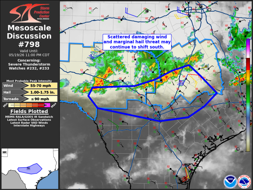
MD 0798 CONCERNING SEVERE THUNDERSTORM WATCH 232…233… FOR CENTRAL TO SOUTH-CENTRAL TEXAS
Mesoscale Discussion 0798
NWS Storm Prediction Center Norman OK
0833 PM CDT Tue May 19 2026

Areas affected...central to south-central Texas

Concerning...Severe Thunderstorm Watch 232...233...

Valid 200133Z - 200400Z

The severe weather threat for Severe Thunderstorm Watch 232, 233
continues.

SUMMARY...A storm complex may consolidate and shift south/southeast
across south-central Texas, with continued threat of locally
damaging winds and marginal hail.

DISCUSSION...Storms have consolidated into a SW-NE oriented line
roughly from Gillespie into Bell/Falls Counties, with recent
propagation to the southeast. Given the robust moisture and
instability in place, along with southeasterly low-level winds into
the complex, it appears likely these storms will maintain intensity
for a few more hours as they move across the Austin area, and
possibly close to San Antonio later this evening. Gusts at or above
50 mph will be possible, along with hail at or above 1.00" diameter.

Farther west, other strong cells are noted along the same aggregate
outflow boundary, from Val Verde into Edwards Counties. The 00Z DRT
sounding does indicate capping above 850 mb, though not particularly
strong, and an MCS appears less likely than farther east.

..Jewell.. 05/20/2026

...Please see www.spc.noaa.gov for graphic product...

ATTN...WFO...HGX...FWD...EWX...SJT...

LAT...LON   30270086 30349931 30559857 30829795 30999733 30659691
            30099633 29689678 29359737 29229841 29610065 29990100
            30270086

MOST PROBABLE PEAK TORNADO INTENSITY...UP TO 90 MPH
MOST PROBABLE PEAK WIND GUST...55-70 MPH
MOST PROBABLE PEAK HAIL SIZE...1.00-1.75 IN
Source link