| Mesoscale Discussion 797 | |
| < Previous MD | |

|
|
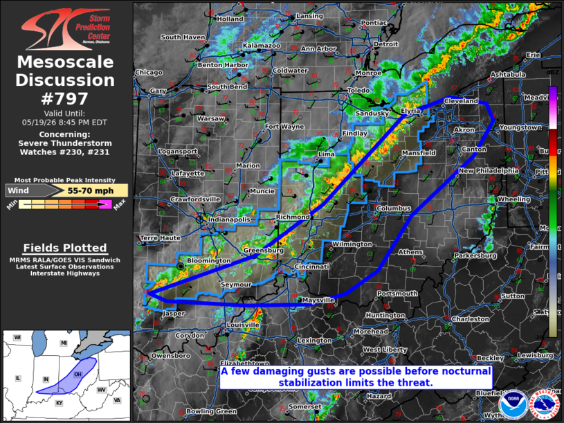
Mesoscale Discussion 0797 NWS Storm Prediction Center Norman OK 0639 PM CDT Tue May 19 2026 Areas affected...portions of eastern and southern Ohio...far southeastern Indiana Concerning...Severe Thunderstorm Watch 230...231... Valid 192339Z - 200045Z The severe weather threat for Severe Thunderstorm Watch 230, 231 continues. SUMMARY...A few damaging gusts are possible over the next couple of hours before boundary layer stabilization occurs. Local WW extensions may be needed if storms can maintain their intensity. DISCUSSION...A persistent elongated MCS continues to track eastward across the eastern OH Valley with a history of widely scattered damaging gusts. Surface temperatures range from the low to mid 80s F ahead of the line, accompanied by 1500-2000 J/kg MLCAPE, suggesting that the boundary layer is still unstable and mixed enough to support a few additional damaging gusts. However, this threat should gradually subside with the loss of daytime heating. Still, WW extensions may be needed if storms persist for more than a couple of hours. ..Squitieri.. 05/19/2026 ...Please see www.spc.noaa.gov for graphic product... ATTN...WFO...PBZ...RLX...CLE...ILN...LMK...IND... LAT...LON 38738717 39338523 40098396 41368243 41628156 41528086 41268073 40768113 39918232 39128295 38808353 38648420 38608539 38648685 38738717 MOST PROBABLE PEAK WIND GUST...55-70 MPH |
|
|
Top/All Mesoscale Discussions/Forecast Products/Home |
|
Source link