| Mesoscale Discussion 794 | |
| < Previous MD | |

|
|
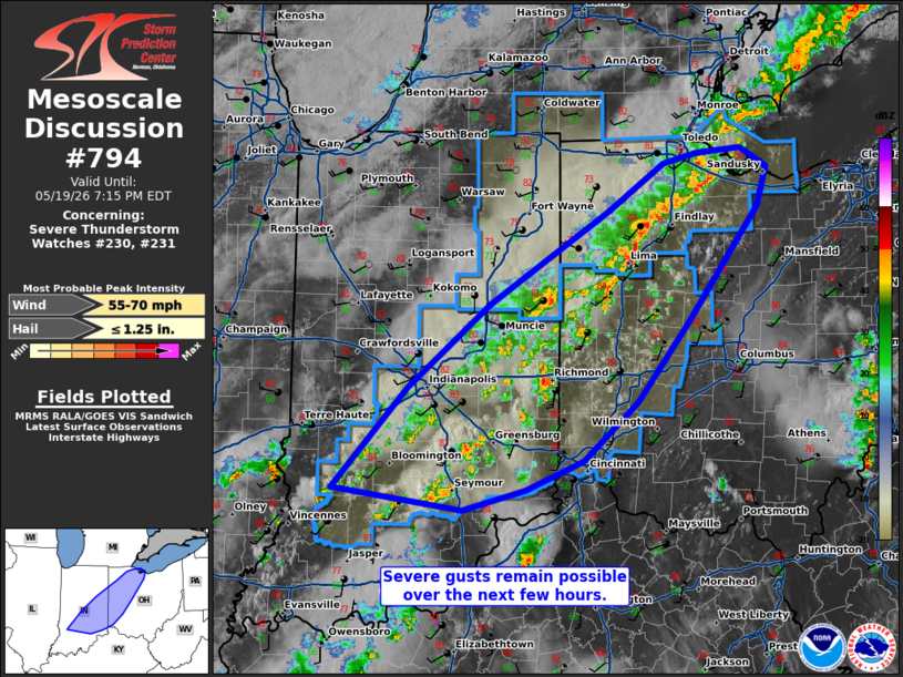
Mesoscale Discussion 0794 NWS Storm Prediction Center Norman OK 0511 PM CDT Tue May 19 2026 Areas affected...eastern Indiana into western Ohio Concerning...Severe Thunderstorm Watch 230...231... Valid 192211Z - 192315Z The severe weather threat for Severe Thunderstorm Watch 230, 231 continues. SUMMARY...A few severe gusts may still occur with the stronger storm cores for the next few hours. DISCUSSION...Multicellular convection is congealing into a semi-organized line of storms, with a history of at least a few damaging gusts. These storms continue to progress eastward ahead of a surface cold front, where surface temperatures in the mid 80s F, amid 60s F dewpoints, are yielding 1500+ J/kg MLCAPE. Vertical shear is relatively weak. Nonetheless, the coverage of storms amid the aforementioned buoyancy suggests that at least a few more damaging gusts may occur over the next few hours. ..Squitieri.. 05/19/2026 ...Please see www.spc.noaa.gov for graphic product... ATTN...WFO...CLE...ILN...DTX...LMK...IWX...IND... LAT...LON 38978710 39748637 41098492 41908371 41958317 41498266 41178276 40268348 39648401 39188456 38958515 38808579 38978710 MOST PROBABLE PEAK WIND GUST...55-70 MPH MOST PROBABLE PEAK HAIL SIZE...UP TO 1.25 IN |
|
|
Top/All Mesoscale Discussions/Forecast Products/Home |
|
Source link