| Mesoscale Discussion 773 | |
| < Previous MD Next MD > | |

|
|
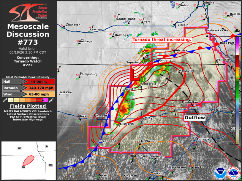
Mesoscale Discussion 0773 NWS Storm Prediction Center Norman OK 0207 PM CDT Mon May 18 2026 Areas affected...North-central Kansas Concerning...Tornado Watch 222... Valid 181907Z - 182030Z The severe weather threat for Tornado Watch 222 continues. SUMMARY...The tornado threat is increasing in parts of north-central Kansas. A strong to intense tornado is possible in this environment. DISCUSSION...Several discrete storms have developed in the vicinity of Concordia, KS. The strongest storm so far is in Lincoln County, KS and has shown signs of increasing inflow and mesocyclone strength. This storm will pose the greatest tornado threat as it will most likely have more residence time in the most favorable environment. Given the location of these storms within the modified outflow with backed surface winds and an expected increase in the 850 mb winds through the afternoon, this activity will be the primary focus for tornado potential over the next 2-3 hours. Surface winds near Great Bend/Russell have trended more westerly, but farther north, where these storms are ongoing, the winds remain more northeasterly/northerly. This at least suggests that the linear forcing will remain weak in the short term and keep discrete modes deeper into the afternoon. ..Wendt.. 05/18/2026 ...Please see www.spc.noaa.gov for graphic product... ATTN...WFO...OAX...TOP...ICT...GID... LAT...LON 38819834 39129822 39509795 39889755 40009728 40069686 39959654 39819645 39629650 39149707 38899765 38769810 38819834 MOST PROBABLE PEAK TORNADO INTENSITY...140-170 MPH MOST PROBABLE PEAK WIND GUST...65-80 MPH MOST PROBABLE PEAK HAIL SIZE...4.00+ IN |
|
|
Top/All Mesoscale Discussions/Forecast Products/Home |
|
Source link