| Mesoscale Discussion 770 | |
| < Previous MD | |

|
|
Mesoscale Discussion 0770
NWS Storm Prediction Center Norman OK
1138 AM CDT Mon May 18 2026
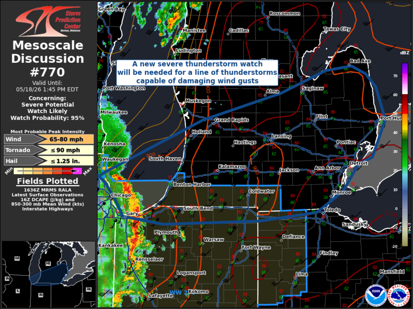
Areas affected...Lower Michigan
Concerning...Severe potential...Watch likely
Valid 181638Z - 181745Z
Probability of Watch Issuance...95 percent
SUMMARY...A new severe thunderstorm watch will be needed as the
northern edge of a QLCS/Bow Echo moves across Lake Michigan and into
lower Michigan.
DISCUSSION...The northern portion of a bow-echo currently moving
across Lake Michigan will pose a threat for damaging winds gusts
across lower and central Michigan this afternoon. Low-level lapse
rates and strong buoyancy will support continued convective
development along the leading edge of the bow echo, and large DCAPE
will support strong downdrafts capable of 65-80 MPH gusts.
..Halbert/Hart.. 05/18/2026
...Please see www.spc.noaa.gov for graphic product...
ATTN...WFO...CLE...DTX...IWX...GRR...LOT...
LAT...LON 41498662 41608738 41868756 42078775 42168788 42268769
43008587 43398434 43718346 43788295 43668267 43468248
42998230 42468257 42378285 41978316 41688366 41568476
41498662
MOST PROBABLE PEAK TORNADO INTENSITY...UP TO 90 MPH
MOST PROBABLE PEAK WIND GUST...65-80 MPH
MOST PROBABLE PEAK HAIL SIZE...UP TO 1.25 IN
|
|
|
Top/All Mesoscale Discussions/Forecast Products/Home |
|
Source link