| Mesoscale Discussion 743 | |
| < Previous MD | |

|
|
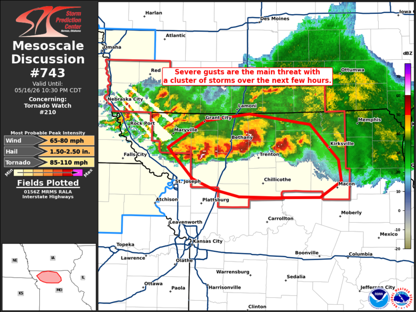
Mesoscale Discussion 0743 NWS Storm Prediction Center Norman OK 0858 PM CDT Sat May 16 2026 Areas affected...portons of northern Missouri Concerning...Tornado Watch 210... Valid 170158Z - 170330Z The severe weather threat for Tornado Watch 210 continues. SUMMARY...A few severe gusts may still occur with an MCS across northern MO over the next few hours. Isolated severe hail remains possible and a tornado cannot be ruled out. DISCUSSION...Multicells and supercells have grown upscale into a southward propagating MCS. A strengthening LLJ is fostering low-level moisture convergence/WAA with this MCS, aiding in its persistence this evening. Given over 2000 J/kg MLCAPE residing ahead of the MCS, a few severe gusts may still occur over the next few hours, before boundary layer stabilization limits wind potential. A few instances of severe hail could also briefly occur with the stronger storm cores. A tornado still cannot be ruled out, either with merging supercell structures, or a resultant embedded mesovortex. ..Squitieri.. 05/17/2026 ...Please see www.spc.noaa.gov for graphic product... ATTN...WFO...EAX... LAT...LON 40199493 40489439 40569375 40459285 40059244 39809240 39639271 39629339 39639389 39729427 39839457 40199493 MOST PROBABLE PEAK TORNADO INTENSITY...85-110 MPH MOST PROBABLE PEAK WIND GUST...65-80 MPH MOST PROBABLE PEAK HAIL SIZE...1.50-2.50 IN |
|
|
Top/All Mesoscale Discussions/Forecast Products/Home |
|
Source link