| Mesoscale Discussion 737 | |
| < Previous MD | |
|
|
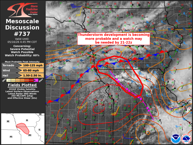
   Mesoscale Discussion 0737
   NWS Storm Prediction Center Norman OK
   0320 PM CDT Sat May 16 2026

   Areas affected...Northern Missouri and southwest Iowa

   Concerning...Severe potential...Watch possible

   Valid 162020Z - 162145Z

   Probability of Watch Issuance...60 percent

   SUMMARY...Thunderstorm development is becoming more probable along a
   residual outflow boundary in Missouri and along a stalled front in
   Iowa.  A watch may be needed by 21-22z.

   DISCUSSION...Visible satellite imagery reveals a gradual
   increase/deepening of cumulus along a residual outflow boundary in
   northern MO, along a stalled front in IA, and in the open warm
   sector into northeast KS.  Farther east, slightly elevated
   convection has shown recent signs of intensification to the cool
   side of the outflow across north central MO.  Continued surface
   heating along and south-through-west of these boundaries will
   continue to weaken inhibition (relatively weak MLCIN modifying the
   18z TOP sounding for 90/64 F), and thunderstorm development will
   become more probable.  The backed low-level flow to the immediate
   cool side of the boundaries will augment vertical shear and support
   supercells capable of producing very large hail, wind damage, and a
   couple of tornadoes.

   ..Thompson/Mosier.. 05/16/2026

   ...Please see www.spc.noaa.gov for graphic product...

   ATTN...WFO...DMX...EAX...OAX...

   LAT...LON   40079295 39759276 39339291 39239323 39509384 40069453
               40339500 40439552 40729569 40989553 41229457 41169408
               41039375 40449327 40079295

   MOST PROBABLE PEAK TORNADO INTENSITY...100-125 MPH
   MOST PROBABLE PEAK WIND GUST...65-80 MPH
   MOST PROBABLE PEAK HAIL SIZE...1.50-2.50 IN
|
|
|
Top/All Mesoscale Discussions/Forecast Products/Home |
|
Source link