| Mesoscale Discussion 641 | |
| < Previous MD | |
|
|
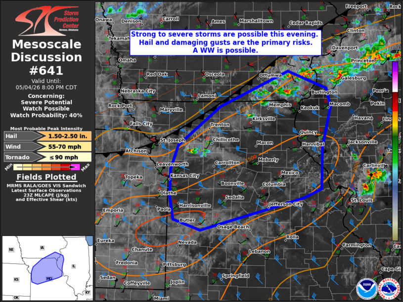
   Mesoscale Discussion 0641
   NWS Storm Prediction Center Norman OK
   0634 PM CDT Mon May 04 2026

   Areas affected...portions of NORTH-central Missouri...southeastern
   iowa and northwestern Illinois

   Concerning...Severe potential...Watch possible

   Valid 042334Z - 050100Z

   Probability of Watch Issuance...40 percent

   SUMMARY...Isolated convective development along the cold front may
   continue to deepen into this evening. Damaging gusts and some hail
   will be possible with clusters or transient supercells. The need for
   a WW is uncertain.

   DISCUSSION...As of 2330 UTC visible and radar imagery showed initial
   thunderstorm development was underway along western portions of the
   slow-moving cold front across southern IA and northern MO.
   Downstream of the front, a warm, but marginally moist air mass
   exists with 1000-1500 J/kg of MLCAPE. 30-40 kt of deep-layer shear
   overspreading the warm sector is sufficient for storm organization
   with clusters and transient supercells possible. Given the steep
   lapse rates in the low and mid-levels (8-9 C/km), damaging gusts are
   possible. The degree of buoyancy could also support some hail risk
   with the stronger updrafts.

   It remains very unclear if these initial storms will survive given
   the presence of dry air throughout the boundary layer immediately
   ahead of the front. Radar trends support this with updrafts and
   reflectively cores being quite small. However, if sufficient
   convection is able to develop and maintain, the more unstable air
   mass farther south could support a severe risk ahead of the cold
   front as depicted by some CAMs this evening. Given the potential for
   some damaging gusts and hail, a WW is possible but highly uncertain.

   ..Lyons/Hart.. 05/04/2026

   ...Please see www.spc.noaa.gov for graphic product...

   ATTN...WFO...ILX...LSX...DVN...SGF...DMX...EAX...

   LAT...LON   40489333 41169166 40839071 40479061 39689084 38929087
               38759131 38139380 38349447 38779455 39289454 39759436
               40489333

   MOST PROBABLE PEAK TORNADO INTENSITY...UP TO 90 MPH
   MOST PROBABLE PEAK WIND GUST...55-70 MPH
   MOST PROBABLE PEAK HAIL SIZE...1.50-2.50 IN
|
|
|
Top/All Mesoscale Discussions/Forecast Products/Home |
|
Source link