| Mesoscale Discussion 628 | |
| < Previous MD | |
|
|
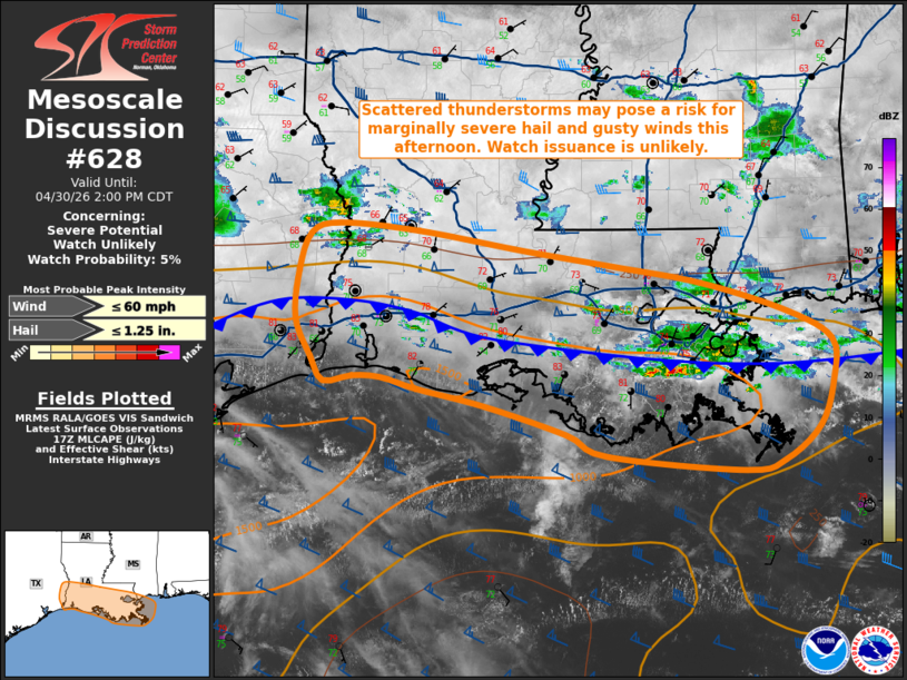
   Mesoscale Discussion 0628
   NWS Storm Prediction Center Norman OK
   1202 PM CDT Thu Apr 30 2026

   Areas affected...portions of extreme eastern Texas into much of
   southern/coastal Louisiana

   Concerning...Severe potential...Watch unlikely

   Valid 301702Z - 301900Z

   Probability of Watch Issuance...5 percent

   SUMMARY...Scattered thunderstorms developing along a cold front will
   pose a risk for marginally severe hail and gusty winds this
   afternoon. Watch issuance is unlikely.

   DISCUSSION...Latest regional radar imagery depicts ongoing
   thunderstorm development along a west-east oriented cold front
   currently analyzed across southern/coastal Louisiana into
   southeastern Texas, with additional development expected through the
   afternoon. The greatest severe potential exists along and south of
   the surface front where greater buoyancy (1000-1500 J/kg MLCAPE per
   latest mesoanalysis) exists owing to surface temperatures near 80 F
   and dewpoints in the mid-70s, with only weakly unstable profiles
   (500 J/kg MUCAPE) based around 850 mb north of the surface front.
   Elongated hodographs and strong westerly flow aloft evident in the
   HDC VWP are contributing to 50+ kts of effective bulk shear that
   will support at least some potential for marginally severe hail and
   gusty winds despite only modestly favorable thermodynamic profiles
   (mid-level lapse rates of 6.5-7.0 C/km per the 12z LIX observed
   sounding and latest RAP forecast soundings). Isolated gusty/damaging
   winds are also possible with any stronger downdrafts, but generally
   weak low-level lapse rates should largely temper wind gust severity.
   Modest 0-3 km CAPE (50-75 J/kg per regional forecast soundings) in
   the presence of enhanced surface vorticity along the surface cold
   front may also promote some potential for an isolated
   landspout/waterspout with stronger updrafts. Watch issuance is
   unlikely owing to the expected limited magnitude of severe
   potential.

   ..Chalmers/Smith.. 04/30/2026

   ...Please see www.spc.noaa.gov for graphic product...

   ATTN...WFO...LIX...LCH...

   LAT...LON   29429214 29579283 29679319 29699348 29639377 29849390
               30189407 30619404 30949391 31049362 30989282 30809174
               30679082 30528994 30258906 30018860 29668859 29248873
               28958909 28868950 28989090 29179131 29429214

   MOST PROBABLE PEAK WIND GUST...UP TO 60 MPH
   MOST PROBABLE PEAK HAIL SIZE...UP TO 1.25 IN
|
|
|
Top/All Mesoscale Discussions/Forecast Products/Home |
|
Source link