| Mesoscale Discussion 627 | |
| < Previous MD | |

|
|
Mesoscale Discussion 0627
NWS Storm Prediction Center Norman OK
1049 AM CDT Thu Apr 30 2026
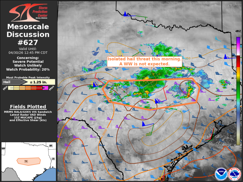
Areas affected...Central Texas
Concerning...Severe potential...Watch unlikely
Valid 301549Z - 301745Z
Probability of Watch Issuance...20 percent
SUMMARY...Isolated occurrences of marginally severe hail are
possible this morning. A watch is not anticipated.
DISCUSSION...Elevated thunderstorms ongoing across portions of the
Concho Valley and Hill Country have exhibited episodic
intensification with volumetric radar data indicating some mid-level
rotation with the strongest storms. The 12z DRT sounding suggests
that convection is likely rooted around 850 mb, with modestly steep
mid-level lapse rates of around 7.5 degrees C/km contributing to
MUCAPE of 2500-3500 J/kg, at least in the Edwards Plateau region.
However, more recent RAP-based forecast soundings suggest that
parcel buoyancy is considerably weaker (500-1000 J/kg) farther east
within the immediate inflow region of the ongoing storms, which may
tend to limit the overall intensity of that convective regime.
Nonetheless, the presence of 55-65 kt of effective bulk shear will
be supportive of transient supercell structures, potentially capable
of marginally severe hail.
Current thinking is that any severe weather threat is expected to
remain too limited in areal coverage and magnitude to warrant the
issuance of a Severe Thunderstorm Watch.
..Mead.. 04/30/2026
...Please see www.spc.noaa.gov for graphic product...
ATTN...WFO...HGX...FWD...EWX...SJT...
LAT...LON 31160059 31510028 31579831 31639608 31219572 30589592
30289822 30620024 31160059
MOST PROBABLE PEAK HAIL SIZE...UP TO 1.25 IN
|
|
|
Top/All Mesoscale Discussions/Forecast Products/Home |
|
Source link