| Mesoscale Discussion 623 | |
| < Previous MD Next MD > | |
|
|
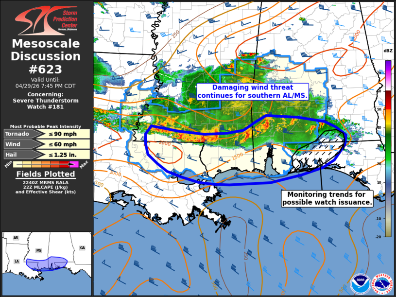
Mesoscale Discussion 0623 NWS Storm Prediction Center Norman OK 0543 PM CDT Wed Apr 29 2026 Areas affected...Southeast Louisiana...southern Mississippi and Alabama Concerning...Severe Thunderstorm Watch 181... Valid 292243Z - 300045Z The severe weather threat for Severe Thunderstorm Watch 181 continues. SUMMARY...Damaging winds remain possible as an MCS slowly pushes south across far southeast Louisiana and southern Mississippi and Alabama. Trends are being monitored for the need for a downstream watch issuance across parts of the Florida Panhandle. DISCUSSION...A squall line continues to push south/southeast with a few wind damage reports noted over the past 1-2 hours. More recently, observed winds have largely been near 35-40 mph and MRMS echo tops shows a slight weakening trend over the past half hour. Additionally, anvil shading downstream of the MCS is cooling surface temperatures, resulting in a gradual decrease in surface-based and mixed-layer CAPE in recent mesoanalyses. Despite this weakening trend, a narrow plume of 1000-1500 J/kg remains in place immediately downstream of the MCS, so some re-intensification appears plausible over the next hour or so before the MCS reaches the coast. Consequently, the potential for damaging winds (most likely between 40-60 mph) will likely persist for the short-term. Further east, the primary bowing segment of the MCS is beginning to approach the Mobile, AL area. Based on recent storm tracks, is appears possible that this section of the line moves into the far western FL Panhandle within the next 1-2 hours. This may require a watch extension or targeted watch issuance if re-intensification of the MCS occurs. ..Moore.. 04/29/2026 ...Please see www.spc.noaa.gov for graphic product... ATTN...WFO...TAE...MOB...JAN...LIX... LAT...LON 30199030 30329071 30509098 30709122 30949130 31179131 31369115 31249041 31219004 31198971 31218912 31298868 31478835 31628806 31588720 31468649 31348619 31218601 31148592 30918597 30588626 30408657 30258714 30078795 30038905 30048945 30078987 30199030 MOST PROBABLE PEAK TORNADO INTENSITY...UP TO 90 MPH MOST PROBABLE PEAK WIND GUST...UP TO 60 MPH MOST PROBABLE PEAK HAIL SIZE...UP TO 1.25 IN |
|
|
Top/All Mesoscale Discussions/Forecast Products/Home |
|
Source link