| Mesoscale Discussion 618 | |
| < Previous MD | |
|
|
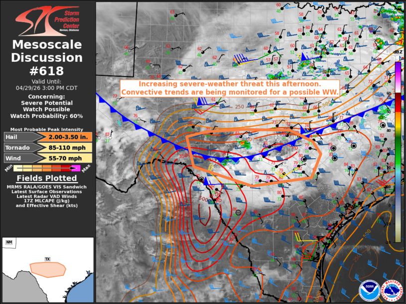
   Mesoscale Discussion 0618
   NWS Storm Prediction Center Norman OK
   1254 PM CDT Wed Apr 29 2026

   Areas affected...Edwards Plateau into the Hill Country of Texas

   Concerning...Severe potential...Watch possible

   Valid 291754Z - 292000Z

   Probability of Watch Issuance...60 percent

   SUMMARY...The threat for severe storms capable of large to very
   large hail and severe wind gusts is expected to increase across the
   discussion area this afternoon. Convective trends are being
   monitored for a possible Severe Thunderstorm Watch.

   DISCUSSION...A couple of thunderstorms have recently intensified
   over Kimble and Edwards Counties, along and in the immediate wake of
   a cold front moving south through the area. A small pocket of
   clearing has developed to the immediate east of that convection,
   which should allow for locally strong diabatic heating to occur. The
   12z DRT sounding sampled a formidable cap at the base of EML;
   however, latest objective analysis suggests that cap is eroding in
   the vicinity of the ongoing storms.

   If the current activity can become rooted in the boundary layer, the
   colocation of a moderate to strongly unstable air mass (MLCAPE of
   2500-3000 J/kg) with effective bulk shear magnitudes of 50-55 knots
   would support evolution into longer-lived supercell structures. The
   predominant hazard would be large to very large hail (2.5-3.5" in
   diameter), with more sporadic occurrences of severe wind gusts.
   While a tornado or two is possible, the overall potential will be
   limited by relatively weak low-level shear and undercutting nature
   of the cold front.

   Convective trends are being monitored for a possible Severe
   Thunderstorm Watch.

   ..Mead/Smith.. 04/29/2026

   ...Please see www.spc.noaa.gov for graphic product...

   ATTN...WFO...EWX...SJT...

   LAT...LON   30470138 29700116 29219941 29419764 30039735 30369759
               30659826 30699968 30620079 30470138

   MOST PROBABLE PEAK TORNADO INTENSITY...85-110 MPH
   MOST PROBABLE PEAK WIND GUST...55-70 MPH
   MOST PROBABLE PEAK HAIL SIZE...2.00-3.50 IN
|
|
|
Top/All Mesoscale Discussions/Forecast Products/Home |
|
Source link