| Mesoscale Discussion 616 | |
| < Previous MD | |

|
|
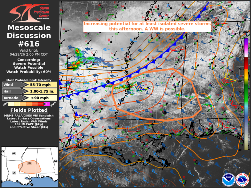
   Mesoscale Discussion 0616
   NWS Storm Prediction Center Norman OK
   1200 PM CDT Wed Apr 29 2026

   Areas affected...northeast Louisiana...central and southern
   Mississippi...and west-central and southwest Alabama

   Concerning...Severe potential...Watch possible

   Valid 291700Z - 291900Z

   Probability of Watch Issuance...60 percent

   SUMMARY...At least isolated severe storms appear probable across the
   discussion area this afternoon. Damaging winds and large hail are
   the primary hazards. Convective trends are being monitored for a
   possible Severe Thunderstorm Watch.

   DISCUSSION...Mosaic radar data as of 1700z indicate showers
   gradually increasing in areal coverage from northeast LA into
   west-central MS, along and ahead of a slow-moving cold front. Breaks
   in the clouds have allowed for stronger daytime heating to occur
   within the pre-frontal warm sector as of late morning. When coupled
   with dewpoints in the low 70s, the air mass is already moderately
   unstable with estimated MLCAPE of 2000-2500 J/kg, per objective
   analysis.

   Current thinking is that the ongoing showers will deepen into
   thunderstorms within the next hour as growing cold pools and frontal
   lift allow parcels to fully realize the available instability. While
   the low-level wind field is expected to remain relatively weak (ref.
   current KDGX VWP), the presence of strong, westerly mid/upper-level
   winds is yielding sufficient deep-layer shear for organized storm
   modes. Modest mid-level lapse rates should temper overall hail
   sizes; however, hail stones up to 1.00-1.75" in diameter will be
   possible with any supercell structures. Damaging wind gusts will
   also be a concern, driven largely by precipitation-loaded
   downdrafts.

   The main uncertainty at present is areal coverage of the
   severe-weather threat. Convective trends are being monitored for a
   possible Severe Thunderstorm Watch.

   ..Mead.. 04/29/2026

   ...Please see www.spc.noaa.gov for graphic product...

   ATTN...WFO...BMX...MOB...JAN...LIX...

   LAT...LON   32049181 32359177 32939025 33088884 32548795 31408750
               31088792 30958913 31039031 31439157 32049181

   MOST PROBABLE PEAK TORNADO INTENSITY...UP TO 90 MPH
   MOST PROBABLE PEAK WIND GUST...55-70 MPH
   MOST PROBABLE PEAK HAIL SIZE...1.00-1.75 IN
|
|
|
Top/All Mesoscale Discussions/Forecast Products/Home |
|
Source link