| Mesoscale Discussion 605 | |
| < Previous MD Next MD > | |
|
|
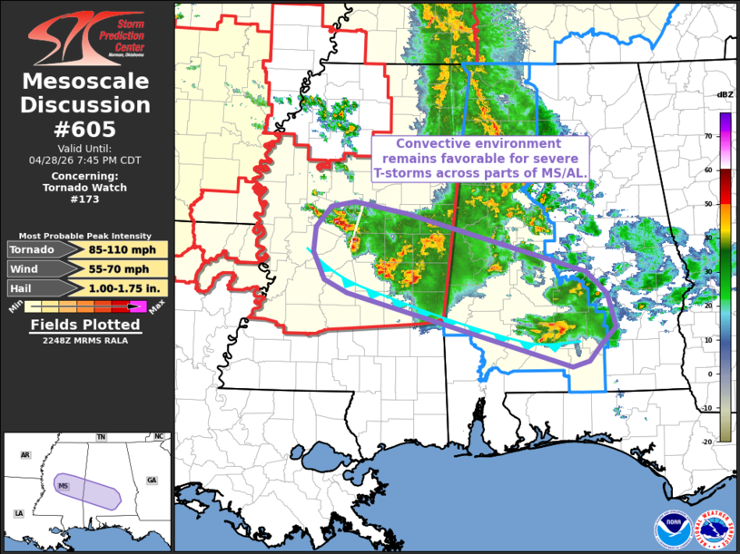
Mesoscale Discussion 0605 NWS Storm Prediction Center Norman OK 0550 PM CDT Tue Apr 28 2026 Areas affected...central Mississippi into southern Alabama Concerning...Tornado Watch 173... Valid 282250Z - 290045Z The severe weather threat for Tornado Watch 173 continues. SUMMARY...The convective environment remains favorable or severe thunderstorms across central Mississippi into parts of southern Alabama. DISCUSSION...Latest radar imagery from KDGX and KGWX shows intensification of a supercell (including a notable three-body scatter spike) north of the Jackson, MS area. Although this storm is likely elevated based on the placement of an outflow boundary (noted in surface observations), a recent 21 UTC sounding from JAN sampled sufficient MUCAPE for robust convection, even when accounting for near-storm conditions within the cold pool. This sounding also sampled effective bulk shear values on the order of 50-60 knots, which is highly favorable for organized convection. As demonstrated by the recent trends in the supercell north of Jackson, MS, this environment should continue to support intensification of ongoing elevated storms and/or development of new convection over the next several hours. ..Moore.. 04/28/2026 ...Please see www.spc.noaa.gov for graphic product... ATTN...WFO...BMX...MOB...JAN... LAT...LON 31298664 32198985 32369018 32699033 32999030 33259008 33318974 33168900 32458644 32188613 31788602 31578621 31378640 31298664 MOST PROBABLE PEAK TORNADO INTENSITY...85-110 MPH MOST PROBABLE PEAK WIND GUST...55-70 MPH MOST PROBABLE PEAK HAIL SIZE...1.00-1.75 IN |
|
|
Top/All Mesoscale Discussions/Forecast Products/Home |
|
Source link