| Mesoscale Discussion 405 | |
| < Previous MD | |
|
|
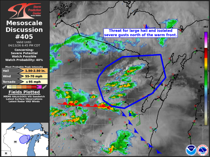
   Mesoscale Discussion 0405
   NWS Storm Prediction Center Norman OK
   0448 PM CDT Mon Apr 13 2026

   Areas affected...Parts of Wolf River Valley into adjacent Upper
   Peninsula of Michigan

   Concerning...Severe potential...Watch possible

   Valid 132148Z - 132345Z

   Probability of Watch Issuance...40 percent

   SUMMARY...Large hail and isolated severe gusts are possible with
   elevated supercells this afternoon/early evening. A watch is
   possible should convective trends in storm intensity warrant.

   DISCUSSION...Storms have begun to develop within the Wolf River
   Valley region. These storms exist north of the warm front. While
   buoyancy is more limited with northern extent, strong shear noted on
   the KGRB VAD and steep mid-level lapse rate on the observed 18Z GRB
   sounding suggests elevated supercells will be capable of large hail
   and isolated severe wind gusts. The warm front will slowly try to
   move northward into the evening, though cooler lake air in the Fox
   River Valley/Sturgeon Bay is noted and will hinder this process to
   some extent. That being said, the overall tornado threat should
   remain low, though it will not be zero for any storm near the warm
   front.

   ..Wendt/Hart.. 04/13/2026

   ...Please see www.spc.noaa.gov for graphic product...

   ATTN...WFO...MQT...GRB...

   LAT...LON   44988766 44628859 44688902 44828929 45258949 45398943
               45608920 45848866 45898737 45348721 44988766

   MOST PROBABLE PEAK TORNADO INTENSITY...UP TO 95 MPH
   MOST PROBABLE PEAK WIND GUST...55-70 MPH
   MOST PROBABLE PEAK HAIL SIZE...1.50-2.50 IN
|
|
|
Top/All Mesoscale Discussions/Forecast Products/Home |
|
Source link