| Mesoscale Discussion 399 | |
| < Previous MD Next MD > | |

|
|
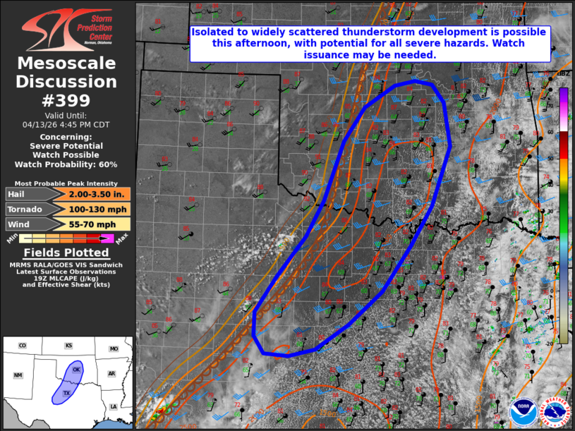
   Mesoscale Discussion 0399
   NWS Storm Prediction Center Norman OK
   0238 PM CDT Mon Apr 13 2026

   Areas affected...portions of northwest Texas into central Oklahoma

   Concerning...Severe potential...Watch possible

   Valid 131938Z - 132145Z

   Probability of Watch Issuance...60 percent

   SUMMARY...Isolated to widely scattered thunderstorm development is
   possible along a dryline this afternoon. Any sustained storms that
   are able to develop will bring the potential for all severe hazards,
   with the primary threat large to very large hail.

   DISCUSSION...Latest surface observations depict a dryline extending
   south-southwestward across western Oklahoma and northwest Texas. An
   area of deepening cumulus is noted in recent visible satellite
   imagery across portions of the Texas Rolling Plains where convective
   temperatures are beginning to be reached amid strong diurnal heating
   and deep boundary layer mixing behind the dryline. Within the warm
   sector, mid-80s temperatures amid mid/upper 60s F dewpoints and
   steep mid-level lapse rates (per 18Z LMN special sounding) are
   contributing to 2000-3000 J/kg MLCAPE.

   While upper-level forcing is forecast to remain modest at best,
   30-40 kts of effective bulk shear amid a belt of enhanced mid-level
   flow (40+ kts at 4-5 km AGL per regional VWPs) will support
   supercells capable of all hazards. The primary threat with any
   storms that do develop is expected to be large to very large hail to
   2-3+ inches in diameter, which is supported by recent mesoanalysis
   that indicates ample buoyancy within the hail growth zone and SHIP
   values of 2+. The tornado threat remains somewhat more conditional
   on a storm persisting into the evening hours when a strengthening of
   the nocturnal low-level jet will yield increasing low-level SRH and
   clockwise hodograph curvature.

   While the timing of potential convective initiation and subsequent
   storm coverage remain somewhat uncertain, a watch will likely be
   needed should initiation appear imminent given the conditionally
   favorable warm sector environment.

   ..Chalmers/Hart.. 04/13/2026

   ...Please see www.spc.noaa.gov for graphic product...

   ATTN...WFO...TSA...FWD...OUN...SJT...

   LAT...LON   31590023 31890044 32320043 32949998 33669938 34289902
               35339860 35939814 36329749 36409705 36339669 36019643
               35239632 34189672 33509717 32699779 32109849 31679918
               31549972 31590023

   MOST PROBABLE PEAK TORNADO INTENSITY...100-130 MPH
   MOST PROBABLE PEAK WIND GUST...55-70 MPH
   MOST PROBABLE PEAK HAIL SIZE...2.00-3.50 IN
|
|
|
Top/All Mesoscale Discussions/Forecast Products/Home |
|
Source link