| Mesoscale Discussion 398 | |
| < Previous MD | |

|
|
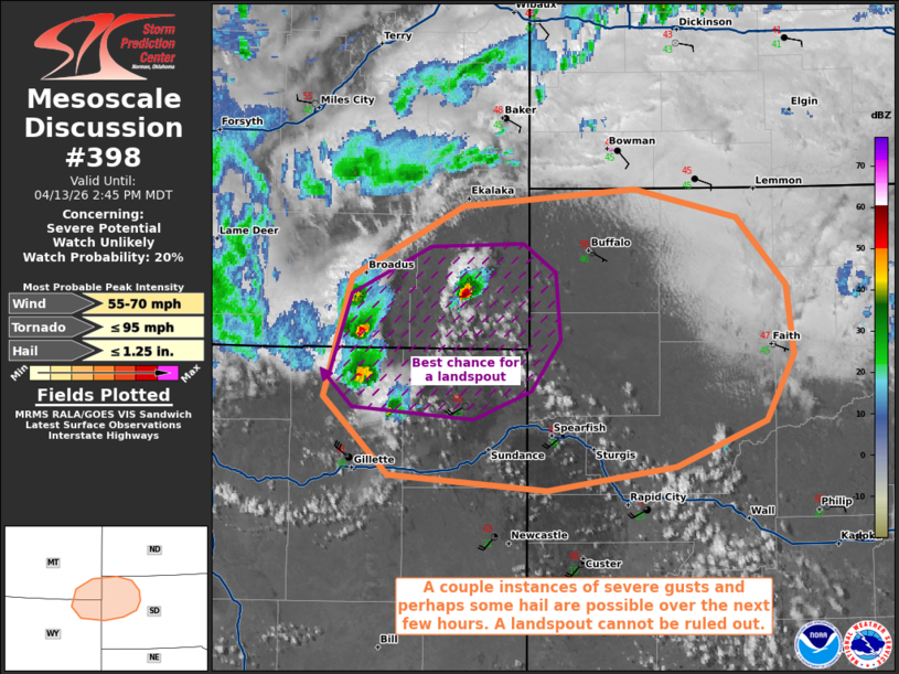
   Mesoscale Discussion 0398
   NWS Storm Prediction Center Norman OK
   0218 PM CDT Mon Apr 13 2026

   Areas affected...portions of extreme southeast Montana into extreme
   northeast Wyoming and far western South Dakota

   Concerning...Severe potential...Watch unlikely

   Valid 131918Z - 132045Z

   Probability of Watch Issuance...20 percent

   SUMMARY...A localized severe threat may develop through the
   afternoon. Severe gusts are the main threat, though a few instances
   of hail and perhaps a landspout tornado are also possible.

   DISCUSSION...Low-topped storms have recently developed near a
   secondary surface low and a low-amplitude mid-level impulse
   overspreads the northern High Plains. Ample surface heating has
   allowed for deep boundary layer mixing, with surface dewpoints in
   the 20s-40s F noted. These storms are likely high-based, and will be
   capable of producing a few severe gusts due to evaporative cooling
   within the deep/dry boundary layer. 19Z mesoanalysis depicts well
   over 100 J/kg 0-3 km CAPE amid very high amounts of low-level
   vertically oriented vorticity. Storms will likely be outflow
   dominant due to evaporative cooling producing extensive cold pools.
   However, any updrafts in this vorticity rich environment that can
   avoid undercutting for appreciable periods of time may support a
   landspout threat, as well as the potential for some hail. Given the
   isolated nature of the severe threat, a WW issuance is not currently
   anticipated.

   ..Squitieri/Hart.. 04/13/2026

   ...Please see www.spc.noaa.gov for graphic product...

   ATTN...WFO...UNR...BYZ...

   LAT...LON   44710575 45410551 45830459 45940316 45770230 45360190
               44950183 44570207 44300281 44160388 44250521 44710575

   MOST PROBABLE PEAK TORNADO INTENSITY...UP TO 95 MPH
   MOST PROBABLE PEAK WIND GUST...55-70 MPH
   MOST PROBABLE PEAK HAIL SIZE...UP TO 1.25 IN
|
|
|
Top/All Mesoscale Discussions/Forecast Products/Home |
|
Source link