| Mesoscale Discussion 394 | |
| < Previous MD | |

|
|
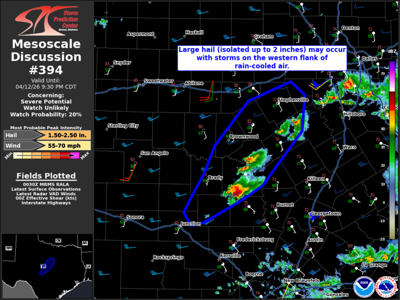
   Mesoscale Discussion 0394
   NWS Storm Prediction Center Norman OK
   0732 PM CDT Sun Apr 12 2026

   Areas affected...Portions of central Texas

   Concerning...Severe potential...Watch unlikely

   Valid 130032Z - 130230Z

   Probability of Watch Issuance...20 percent

   SUMMARY...Large hail (isolated up to 2 inches) and severe wind gusts
   are possible into mid evening with storms in central Texas. A watch
   is not anticipated given limited forcing and storm coverage.

   DISCUSSION...Storms in the vicinity of San Saba and Mills Counties
   have intensified over the last hour. These storms are forming along
   the western edge of rain-cooled air from convection farther east.
   This evening's observed soundings from the region indicate steep
   mid-level lapse rates (7.5-8 C/km). While mid-level winds will tend
   to weaken with time, storms will remain at least periodically
   organized into the evening. Given the relatively straight
   hodographs, storm splits can be expected. The greatest potential for
   severe weather (particularly large hail) will be from left-moving
   cells. These storms will maintain warm/moist inflow as they move
   north-northeast away from the cooler air. How long storms can remain
   strong to severe is not certain given lack of large-scale forcing.

   ..Wendt/Hart.. 04/13/2026

   ...Please see www.spc.noaa.gov for graphic product...

   ATTN...WFO...FWD...EWX...SJT...

   LAT...LON   31069844 30889874 30559937 30509958 30689970 30849963
               31249938 31619921 32259866 32519796 32339773 31829778
               31069844

   MOST PROBABLE PEAK WIND GUST...55-70 MPH
   MOST PROBABLE PEAK HAIL SIZE...1.50-2.50 IN
|
|
|
Top/All Mesoscale Discussions/Forecast Products/Home |
|
Source link