| Mesoscale Discussion 386 | |
| < Previous MD | |

|
|
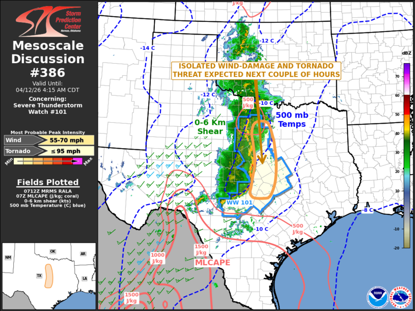
Mesoscale Discussion 0386 NWS Storm Prediction Center Norman OK 0214 AM CDT Sun Apr 12 2026 Areas affected...Central and North Texas Concerning...Severe Thunderstorm Watch 101... Valid 120714Z - 120915Z The severe weather threat for Severe Thunderstorm Watch 101 continues. SUMMARY...An isolated threat for severe wind gusts and potential for a tornado or two will continue over the next few hours across parts of central and north Texas. DISCUSSION...A line of strong thunderstorms is ongoing across northern sections of the Texas Hill Country. Ahead of the line, a moist airmass is in place with surface dewpoint in the mid 60s F. The RAP has weak instability over this moist airmass, with MLCAPE generally around 500 J/kg. The line is moving towards an axis of strong low-level flow, in which short-term model forecasts continue to strengthen late tonight into early this morning. In response, surface dewpoints will gradually rise, as a 50 knot speed max at 850 mb develops ahead of the ongoing line of storms. This should help maintain a severe threat over the next few hours. Isolated severe wind gusts and perhaps a tornado or two will be possible, mainly with rotating elements embedded in the line. ..Broyles.. 04/12/2026 ...Please see www.spc.noaa.gov for graphic product... ATTN...WFO...FWD...EWX... LAT...LON 32309732 31659725 30919731 30389754 30299782 30309819 30389833 30529842 30719837 31169828 31639820 32399829 32769834 33109825 33229798 33159761 32629740 32309732 MOST PROBABLE PEAK TORNADO INTENSITY...UP TO 95 MPH MOST PROBABLE PEAK WIND GUST...55-70 MPH |
|
|
Top/All Mesoscale Discussions/Forecast Products/Home |
|
Source link