| Mesoscale Discussion 317 | |
| < Previous MD | |
|
|
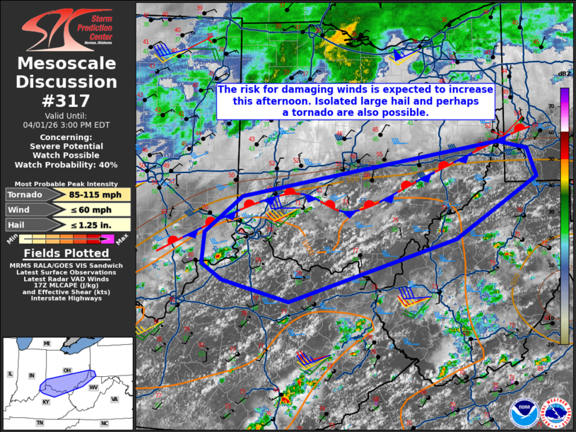
   Mesoscale Discussion 0317
   NWS Storm Prediction Center Norman OK
   1206 PM CDT Wed Apr 01 2026

   Areas affected...Parts of middle/upper Ohio Valley

   Concerning...Severe potential...Watch possible

   Valid 011706Z - 011900Z

   Probability of Watch Issuance...40 percent

   SUMMARY...A general increase in storm coverage and intensity is
   expected within a moist airmass in the middle/upper Ohio Valley this
   afternoon. Damaging winds are the main hazard along with more
   limited potential for a tornado or large hail. Storm coverage trends
   will be monitored this afternoon. A watch is possible should trends
   warrant.

   DISCUSSION...MLCIN has generally eroded in the middle/upper Ohio
   Valley early this afternoon as cumulus clouds have become more
   prevalent on visible satellite. A couple of deeper
   updrafts/thunderstorms have recently developed between Louisville
   and Cincinnati. As the surface continues to heat this afternoon, the
   expectation is for additional storms to develop and intensify along
   a stationary boundary. This activity will be aided be upstream,
   subtle shortwave trough in Illinois/Indiana. Effective shear of
   around 35 kts will promote marginal supercell structures. Damaging
   wind gusts are the primary hazard with these storms. A conditional
   tornado threat will exist right along the boundary, though low-level
   shear rapidly decreases into the warm sector. Mid-level lapse rates
   from this morning's soundings were poor, but isolated large hail
   would be possible with supercells. The primary question is how large
   the spatial extent of the severe threat will become. Such subtle
   forcing for ascent may mean a generally cellular mode with more
   isolated wind damage potential. Some CAM solutions do suggest
   clustering is possible which would increase the wind damage threat
   at least locally.

   ..Wendt/Hart.. 04/01/2026

   ...Please see www.spc.noaa.gov for graphic product...

   ATTN...WFO...PBZ...RLX...JKL...ILN...LMK...

   LAT...LON   38248397 38518505 38708537 39098532 39558473 39828323
               40238063 40148016 39788001 39018131 38248397

   MOST PROBABLE PEAK TORNADO INTENSITY...85-115 MPH
   MOST PROBABLE PEAK WIND GUST...UP TO 60 MPH
   MOST PROBABLE PEAK HAIL SIZE...UP TO 1.25 IN
|
|
|
Top/All Mesoscale Discussions/Forecast Products/Home |
|
Source link