| Mesoscale Discussion 301 | |
| < Previous MD | |
|
|
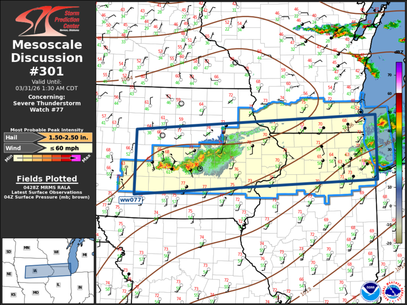
Mesoscale Discussion 0301 NWS Storm Prediction Center Norman OK 1129 PM CDT Mon Mar 30 2026 Areas affected...Central Iowa to southern Lake Michigan Concerning...Severe Thunderstorm Watch 77... Valid 310429Z - 310630Z The severe weather threat for Severe Thunderstorm Watch 77 continues. SUMMARY...Large hail threat continues with storms tonight, along with some risk for gusty winds. DISCUSSION...Back edge of a short-wave trough appears to extend from southwest MN-eastern NE. Scattered deep convection has developed ahead of this feature, partially aided by a strong but veered LLJ. Sustained low-level warm advection will continue much of the night along this corridor so new development is possible in addition to the two main clusters that are currently observed. Latest MESH data suggests large hail is noted within the stronger updrafts in these clusters, and this should be the primary concern into the early morning hours. ..Darrow.. 03/31/2026 ...Please see www.spc.noaa.gov for graphic product... ATTN...WFO...LOT...MKX...DVN...ARX...DMX... LAT...LON 42549463 42878745 41438746 41109466 42549463 MOST PROBABLE PEAK WIND GUST...UP TO 60 MPH MOST PROBABLE PEAK HAIL SIZE...1.50-2.50 IN |
|
|
Top/All Mesoscale Discussions/Forecast Products/Home |
|
Source link