| Mesoscale Discussion 273 | |
| < Previous MD | |
|
|
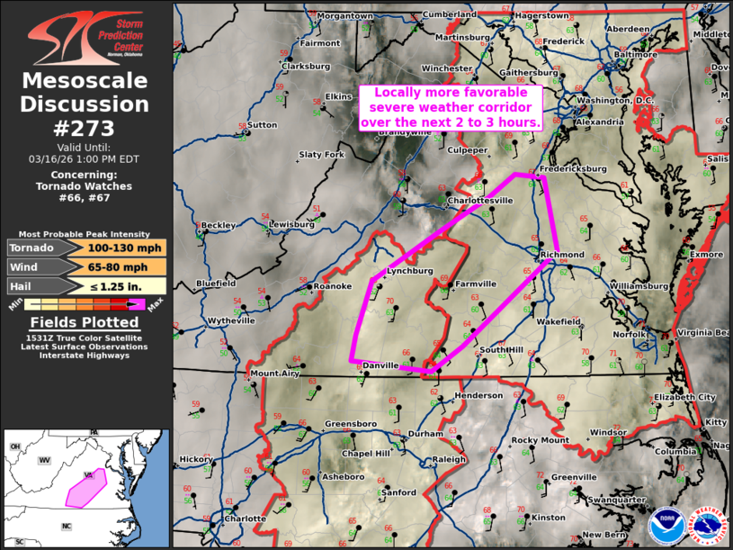
Mesoscale Discussion 0273 NWS Storm Prediction Center Norman OK 1035 AM CDT Mon Mar 16 2026 Areas affected...portions of central Virginia Concerning...Tornado Watch 66...67... Valid 161535Z - 161700Z The severe weather threat for Tornado Watch 66, 67 continues. SUMMARY...A locally more favorable severe weather corridor exists over the next 2 to 3 hours across portions of central Virginia. DISCUSSION...Temperatures have increased to the mid to upper 60s in a narrow zone from south-central Virginia into east-central Virginia late this morning. Some breaks in the clouds remain across this region which may permit some additional warming. The line of storms near the NC/VA border are also more favorably oriented for a greater damaging wind/QLCS tornado threat. Additionally, mid-level flow is rapidly strengthening with the FCX VWP showing mid-level flow increasing from 60 knots to 80 knots over the last 2 hours. Therefore, this corridor from Halifax to Hanover County may have a greater severe weather threat over the next 2 to 3 hours. ..Bentley/Thompson.. 03/16/2026 ...Please see www.spc.noaa.gov for graphic product... ATTN...WFO...AKQ...LWX...RNK... LAT...LON 36587862 36687950 36917945 37387927 37827853 38117799 38317770 38287739 37637725 36807829 36587862 MOST PROBABLE PEAK TORNADO INTENSITY...100-130 MPH MOST PROBABLE PEAK WIND GUST...65-80 MPH MOST PROBABLE PEAK HAIL SIZE...UP TO 1.25 IN |
|
|
Top/All Mesoscale Discussions/Forecast Products/Home |
|
Source link