| Mesoscale Discussion 255 | |
| < Previous MD | |
|
|
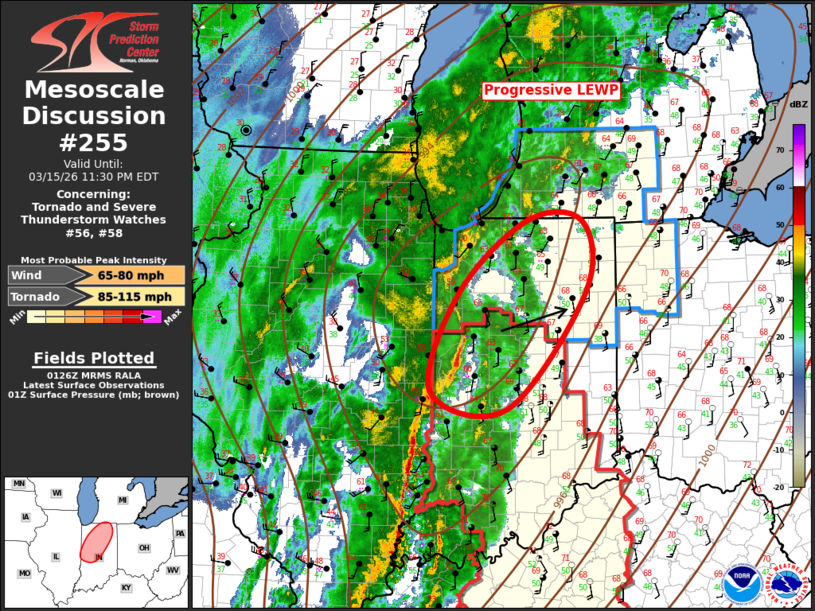
   Mesoscale Discussion 0255
   NWS Storm Prediction Center Norman OK
   0829 PM CDT Sun Mar 15 2026

   Areas affected...Indiana

   Concerning...Tornado and Severe Thunderstorm Watches 56...58...

   Valid 160129Z - 160330Z

   The severe weather threat for Tornado and Severe Thunderstorm
   Watches 56, 58 continues.

   SUMMARY...Damaging winds remain likely with a progressive squall
   line this evening. Isolated tornado risk continues as well.

   DISCUSSION...Long-lived linear MCS (LEWP) continues its forward
   propagation across the Midwest. Leading edge of this strongly forced
   line is advancing across western IN, and several bowing structures
   are surging northeast along this line. One of these features is
   currently over Fountain/Warren County and it will quickly spread
   downstream across Lafayette with an attendant risk for severe. With
   time, this complex of storms should propagate across the remainder
   of the State of IN into Lower MI over the next several hours.

   ..Darrow.. 03/16/2026

   ...Please see www.spc.noaa.gov for graphic product...

   ATTN...WFO...IWX...IND...LOT...ILX...

   LAT...LON   39788756 40928713 41738611 41728529 40918525 39588641
               39788756

   MOST PROBABLE PEAK TORNADO INTENSITY...85-115 MPH
   MOST PROBABLE PEAK WIND GUST...65-80 MPH
|
|
|
Top/All Mesoscale Discussions/Forecast Products/Home |
|
Source link