| Mesoscale Discussion 249 | |
| < Previous MD Next MD > | |

|
|
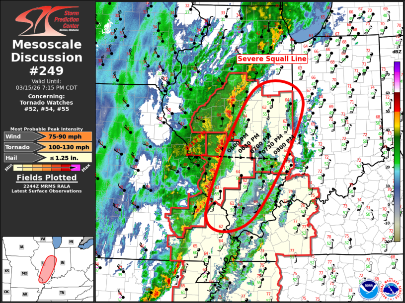
Mesoscale Discussion 0249 NWS Storm Prediction Center Norman OK 0547 PM CDT Sun Mar 15 2026 Areas affected...Illinois and southeast Missouri Concerning...Tornado Watch 52...54...55... Valid 152247Z - 160015Z The severe weather threat for Tornado Watch 52, 54, 55 continues. SUMMARY...Severe squall line is propagating steadily east this evening. Damaging winds are expected, along with a risk for a few tornadoes. DISCUSSION...Mature squall line is propagating east at roughly 30-35kt across central IL into southeast MO. This LEWP is likely producing damaging winds, and several bow-head type circulations are evident along the leading edge of the linear MCS. Air mass is not particularly unstable, but VWX and PAH vad winds exhibit more than 300 0-3km SRH, along with strong speed shear. In addition, intense midlevel height falls favor this strongly forced band of convection to advance into western portions of IN shortly after 01z. ..Darrow.. 03/15/2026 ...Please see www.spc.noaa.gov for graphic product... ATTN...WFO...IND...PAH...LOT...ILX...LSX... LAT...LON 37569012 40508872 40218720 37528870 37569012 MOST PROBABLE PEAK TORNADO INTENSITY...100-130 MPH MOST PROBABLE PEAK WIND GUST...75-90 MPH MOST PROBABLE PEAK HAIL SIZE...UP TO 1.25 IN |
|
|
Top/All Mesoscale Discussions/Forecast Products/Home |
|
Source link