| Mesoscale Discussion 248 | |
| < Previous MD | |

|
|
Mesoscale Discussion 0248
NWS Storm Prediction Center Norman OK
0516 PM CDT Sun Mar 15 2026
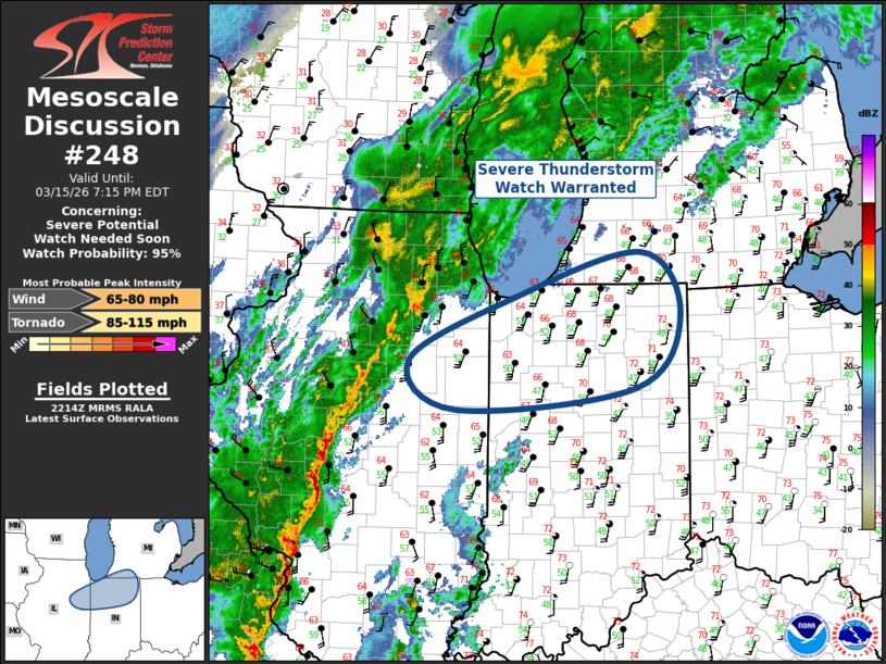
Areas affected...Northeast Illinois-Northern Indiana-Southwest Lower
Michigan
Concerning...Severe potential...Watch needed soon
Valid 152216Z - 152315Z
Probability of Watch Issuance...95 percent
SUMMARY...Severe Thunderstorm Watch will likely be issued soon for
portions of northeast Illinois, northern Indiana, and southwest
Lower Michigan.
DISCUSSION...Leading edge of strongly forced squall line is
advancing steadily east across western/northern IL. While low-level
moisture is somewhat lacking downstream, with upper 40s/lower 50s
surface dew points, cooling/moistening midlevel profiles favor weak
destabilization over the next few hours. Strong shear supports
damaging winds, and perhaps a brief tornado, with this forced line
of convection and a Severe Thunderstorm Watch appears warranted.
..Darrow/Smith.. 03/15/2026
...Please see www.spc.noaa.gov for graphic product...
ATTN...WFO...IWX...GRR...IND...LOT...ILX...
LAT...LON 40978861 41628718 42098543 41458489 40678551 40458798
40978861
MOST PROBABLE PEAK TORNADO INTENSITY...85-115 MPH
MOST PROBABLE PEAK WIND GUST...65-80 MPH
|
|
|
Top/All Mesoscale Discussions/Forecast Products/Home |
|
Source link