| Mesoscale Discussion 217 | |
| < Previous MD Next MD > | |

|
|
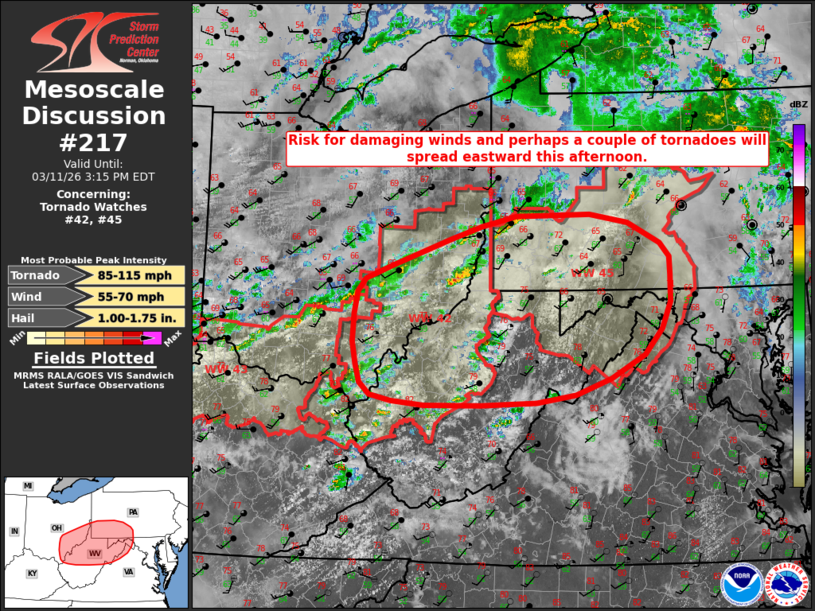
Mesoscale Discussion 0217 NWS Storm Prediction Center Norman OK 1250 PM CDT Wed Mar 11 2026 Areas affected...portions of the upper Ohio River Valley into the northern Mid-Atlantic Concerning...Tornado Watch 42...45... Valid 111750Z - 111915Z The severe weather threat for Tornado Watch 42, 45 continues. SUMMARY...Thunderstorms will gradually spread eastward through this afternoon within an environment supportive of a mix of line segments and supercells. Damaging wind gusts, a couple of tornadoes, and perhaps isolated large hail are possible. DISCUSSION...Several low-topped supercells have exhibited some strengthening across portions of eastern Ohio over the past 30 minutes. This activity, along with additional development, is expected to persist eastward into this afternoon. Filtered diurnal heating of a moist low-level air mass (dewpoints in the upper 50s to low 60s F) is expected to support 1000-1500 J/kg MLCAPE this afternoon amidst strong deep-layer shear of 50+ kts. As increasing upper-level ascent overspreads the region, convective coverage is forecast to increase, with a mix of supercells and line segments expected through the afternoon. While poor mid-level lapse rates are expected to limit the overall threat, strong low-level flow (60+ kts at 1 km AGL per the PBZ VWP) will yield enough low-level shear to support some risk for damaging wind gusts and a couple of tornadoes. Any supercells that are able to remain discrete may also pose a risk for isolated large hail given the aforementioned strong deep-layer shear. ..Chalmers/Gleason.. 03/11/2026 ...Please see www.spc.noaa.gov for graphic product... ATTN...WFO...CTP...LWX...PBZ...RLX...ILN... LAT...LON 38398150 38448198 38518230 38658245 38868251 39128257 39448254 39698250 39848238 40008197 40318111 40468065 40578012 40587961 40607902 40507846 40267798 40097784 39897783 39587782 39277795 38977822 38707871 38507924 38427983 38388066 38398150 MOST PROBABLE PEAK TORNADO INTENSITY...85-115 MPH MOST PROBABLE PEAK WIND GUST...55-70 MPH MOST PROBABLE PEAK HAIL SIZE...1.00-1.75 IN |
|
|
Top/All Mesoscale Discussions/Forecast Products/Home |
|
Source link