| Mesoscale Discussion 181 | |
| < Previous MD | |

|
|
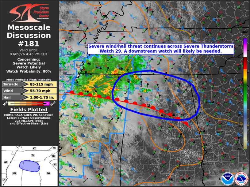
   Mesoscale Discussion 0181
   NWS Storm Prediction Center Norman OK
   0321 PM CDT Mon Mar 09 2026

   Areas affected...portions of northern Alabama and Mississippi into
   southern Tennessee

   Concerning...Severe potential...Watch likely

   Valid 092021Z - 092145Z

   Probability of Watch Issuance...80 percent

   SUMMARY...The threat for severe wind/hail continues across Severe
   Thunderstorm Watch 29. Downstream watch issuance will likely be
   needed by 21 UTC.

   DISCUSSION...An ongoing cluster of thunderstorms across portions of
   northern Mississippi and southern Tennessee will continue to pose a
   risk for severe hail/wind over the next few hours as it tracks
   eastward along a surface warm front. South of this boundary,
   continued low-level moist advection amidst filtered diurnal heating
   has yielded increasing buoyancy. Coupled with increasing mid-level
   flow ahead of a subtle mid-level shortwave trough, the potential
   continues to exist for some intensification with this cluster as it
   progresses eastward. The greatest potential for intensification is
   expected along the southern periphery of the cluster in close
   proximity to the surface warm front where 1000-1500 J/kg MLCAPE and
   35-45 kts of effective bulk wind shear will continue to support the
   potential for some embedded supercell structures along with a risk
   of severe wind/hail with stronger updrafts. With time, a modest
   strengthening of a southerly, low-level jet may also support the
   potential for an isolated tornado. While trends remain a bit
   uncertain, a downstream Severe Thunderstorm Watch will likely be
   needed in the next hour.

   ..Chalmers/Thompson.. 03/09/2026

   ...Please see www.spc.noaa.gov for graphic product...

   ATTN...WFO...FFC...OHX...BMX...HUN...MEG...

   LAT...LON   33398604 33458666 33628764 33788823 33918861 34098880
               34388884 34698873 34918852 35008832 35108781 35138724
               35058681 34938626 34798573 34608543 34458535 34208519
               33898516 33598530 33428561 33398604

   MOST PROBABLE PEAK TORNADO INTENSITY...85-115 MPH
   MOST PROBABLE PEAK WIND GUST...55-70 MPH
   MOST PROBABLE PEAK HAIL SIZE...1.00-1.75 IN
|
|
|
Top/All Mesoscale Discussions/Forecast Products/Home |
|
Source link