| Mesoscale Discussion 179 | |
| < Previous MD | |
|
|
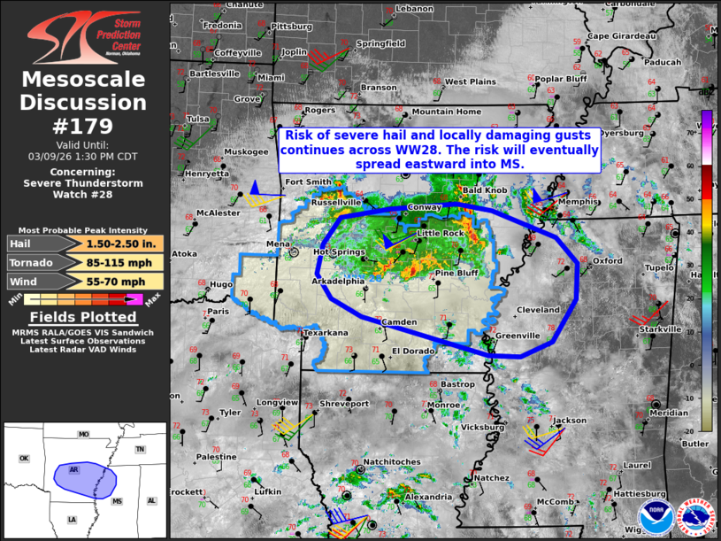
Mesoscale Discussion 0179 NWS Storm Prediction Center Norman OK 1203 PM CDT Mon Mar 09 2026 Areas affected...Parts of southern/central AR into northwest MS Concerning...Severe Thunderstorm Watch 28... Valid 091703Z - 091830Z The severe weather threat for Severe Thunderstorm Watch 28 continues. SUMMARY...The risk of severe hail and locally damaging gusts continues across Severe Thunderstorm Watch #28, and will gradually spread eastward into MS -- where a new watch may eventually be needed. DISCUSSION...A cluster of thunderstorms continues tracking eastward across central AR, with deeper/embedded cores noted along the southern fringes of this activity. As low-level moisture continues streaming northward amid filtered diurnal heating, the stronger cores capable of producing severe hail and locally damaging gusts may remain focused over the southern periphery of the larger cluster. With time, these storms will continue spreading eastward into northern/central MS, with additional warm-advection-driven development also possible. Increasing buoyancy into this corridor and around 40 kt of effective shear will promote a continued risk of large hail and damaging gusts. While timing is uncertain, a downstream watch may eventually be needed. ..Weinman.. 03/09/2026 ...Please see www.spc.noaa.gov for graphic product... ATTN...WFO...MEG...JAN...LZK...SHV... LAT...LON 34669373 35029346 35139268 35219162 35119106 34769006 34428972 33948976 33409013 33209064 33229113 33729312 33969360 34279383 34669373 MOST PROBABLE PEAK TORNADO INTENSITY...85-115 MPH MOST PROBABLE PEAK WIND GUST...55-70 MPH MOST PROBABLE PEAK HAIL SIZE...1.50-2.50 IN |
|
|
Top/All Mesoscale Discussions/Forecast Products/Home |
|
Source link